
5. Watercourses
Sites Adjacent to Watercourses
Context to Bexley's rivers
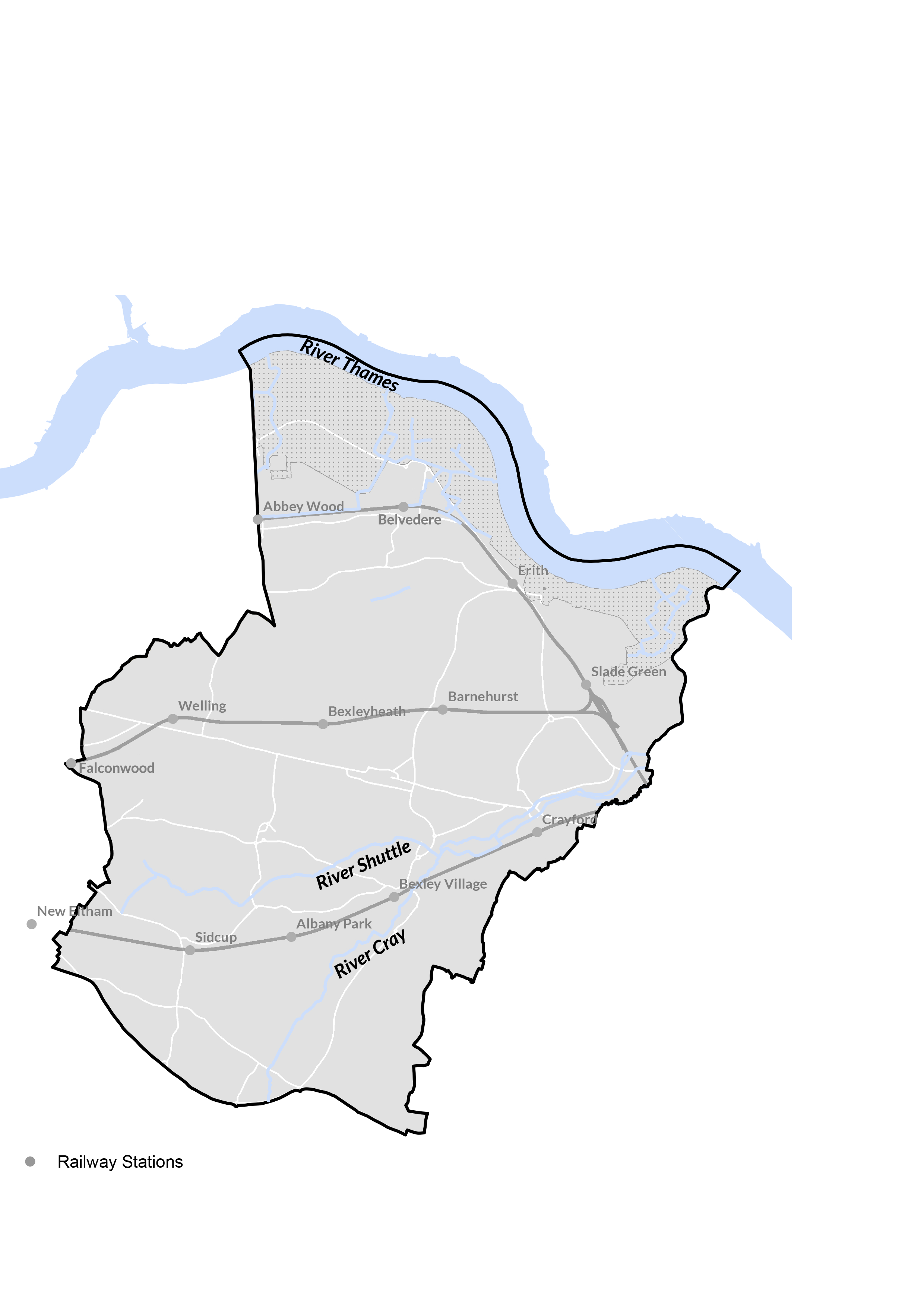
In addition to the River Thames, which gives the borough its northern border, Bexley has two main rivers running through it - River Cray and River Shuttle. A section of the River Darent runs along the borough's eastern boundary. Rivers Cray and Darent are chalk streams, globally rare and precious habitats, rich in wildlife and boasting extremely pure water. All four rivers are designated as Sites of Importance for Nature Conservation (SINC) and their protection and preservation is a priority for the Council.
There is a network of dykes in Belvedere and Crayford which are classified by the Environment Agency (EA) as main rivers. These are home to fish, aquatic plants and invertebrates, as well as rare water vole and birds like kingfishers and provide important green corridors for people and wildlife.
Development adjacent to these rivers can present flood risk and drainage issues that must be addressed to enable proposed development. Such issues can present limitations to development coming forward, principally due to borough-wide capacity issues in sewerage infrastructure and EA requirements that inform the extent of built form permitted along rivers. All development in flood risk areas should demonstrate how it is adaptable for higher floor levels and risk as the climate continues to change.
Riverside development also presents many opportunities and a holistic approach to riverside development is essential to maximising the quality of the riverside. As such, developers are encouraged to work with neighbouring site owners to establish benefits for local communities.
Produced by the Environment Agency (EA), the Thames Estuary 2100 Riverside Strategy Approach identifies the work required to protect land adjacent to the River Thames from flooding risk through the raising of flood defences incrementally by 2100. The TE2100 Plan identifies known intervention points, such as the expected requirement for the first stage of downstream tidal defence upgrades by 2040. This will alleviate pressure on the existing Thames Barrier and extend the time until major upgrade or replacement is required.
Raising the flood defences presents opportunities to enhance the resident and visitor experience of the riverside, improve biodiversity and highlight the importance of the riverside.
Through the Port of London Act 1968 (as amended), the Port of London Authority (PLA) has the primary responsibility to maintain safe access and manage and support the safety of vessels, the public and all users of the River Thames.
Port of London Authority – A Safer Riverside provides best practice guidance for development alongside and on the tidal River Thames to ensure developers consider the potential risks to those using riverside developments and incorporate design features that mitigate this risk whilst enabling people to enjoy the river. The guidance reinforces the importance of ensuring sufficient provision of public rescue equipment (PRE) at high-risk locations and at all new developments and crossings along the Thames.
Applicants should also refer to the Estuary Edges guidance by the Thames Estuary Partnership which provides design principles to maximise the ecological value of the riverside on land and in water.
Figure 21
Fig.21 Bexley's main rivers
Sites Adjacent to Waterways
A 12 Waterfront development should balance people's enjoyment of waterways with adequate life and ecological protection
Bexley Local Plan Policy DP18 Waterfront development and development including, or close to, flood defences, is clear in the importance of development activating spaces along the waterfront and maintaining and creating new access that is safe, whilst protecting and enhancing biodiversity and mitigating the negative impact of development. Policy DP19 The River Thames and the Thames Policy Area sets out the importance of proposals within this area considering the impacts of their development on the ecology of the River, its priority habitats and protected species, with ecological enhancements sought from all proposals.
London Plan Policy SI 17 Protecting and enhancing London's waterways outlines the need for development proposals to respect, support and improve the protection of the distinct character, heritage and biodiversity of the waterways.
4.1 Prior to developing their proposal, applicants are strongly encouraged to develop a Riverside Strategy Approach (RSA) to understand the opportunities and constraints of a development site from the outset, before using this to shape a proposal. An RSA should comprehensively outline how the development will be managed and protected to ensure the long-term sustainability and resilience of riverside environments. Fig. 22 sets out details applicants should consider and include within their RSA.
4.2 Undertaking the RSA will identify that the EA has several design guidelines that will influence the extent of development and that aim to balance protecting natural features and allowing people to enjoy them. Some of these are listed in Fig. 23 overleaf, however applicants should note this list is not exhaustive and early engagement with the EA is strongly encouraged to identify the full extent of design guidelines and any site specific considerations.
Figure 22
Fig.22 Details to be included in a Riverside Strategy Approach
| Topic | What should be addressed? |
|---|---|
| Flood risk management | How communities and their infrastructure will be protected from flooding through both natural and engineered defences, as outlined in this chapter; consideration for how floodplain restoration and natural water retention can be incorporated; how the development site, or part thereof, is not required for present or future flood risk management infrastructure |
| Environmental protection and enhancement | Preserving and restoring riparian habitats and biodiversity; improving water quality by reducing pollution runoff and managing land use |
| Land use planning | Guiding where and how development occurs along the river to minimise environmental impacts and flood risk through methods that require minimal interventions such as introducing setbacks and buffer zones |
| Public access and restoration | Providing safe and enjoyable access to riverside areas using parks, trails and recreational facilities that encourage community engagement and stewardship of the river; supporting population health by enabling and encouraging physical activity and contact with nature |
| Cultural and heritage conservation | Protecting historic sites, landscapes and views connected to the river |
| Economic development | Supporting sustainable river-based economic activities that can bolster the local community |
| Integrated stakeholder collaboration | Involving key stakeholders in both planning and implementation, including local community members and groups, environmental groups, businesses, agencies such as the EA and the Port of London Authority (PLA) |
Figure 23
Fig.23 Examples of Environment Agency design guidelines
- Applicants should develop and implement a Riverside Strategy Approach (RSA) to development.
- Proposals should accommodate a minimum 16m setback for all development along the Thames Tidal Flood Defences, in which no built structures should be proposed.
- This setback can be used to accommodate communal amenity space, but this cannot impede the maintenance of the flood defences.
- Ecological, main river buffer zones should have a separate area for biodiversity and recreational open space, ensuring people don't disturb the area whilst balancing connection with the river.
- Biodiversity enhancements to the buffer zone and riverbank should be proposed.
- The EA is supportive of reducing the carbon impact of constructing flood defences, and applicants should demonstrate that the defences will have a residual life commensurate with the development.
- Proposals should not obstruct reasonable levels of daylight and sunlight into main rivers and buffer zones to ensure the protection of ecological habitats.
- Access to flood defences for repair, inspection, maintenance and future raising or replacement is required and should be considered in any proposals.
- Lighting design within the buffer zone should take ecology into consideration.
- Signage near ecological buffer zones and habitats should be installed to enhance public knowledge and understanding, whilst also aiding with safety along these areas.
4.3 These guidelines, along with other constraints and opportunities of an individual site, should be responded to creatively. The 16m setback, for example, can provide opportunities to enhance the townscape and people's enjoyment of the place through delivering public realm that improves access to nature and ecology.
4.4 Some activities and uses typically permitted within the riverside setback include:
- natural vegetation and habitat restoration, which is encouraged to maintain or restore native plants to stabilise riverbanks, provide habitats and a riparian buffer
- low-impact access and recreational uses such as footpaths and docks that will not negatively impact the riverside and enable riverside access
- agricultural activities like gardens and landscaping that do not harm the water quality or riverbank stability
- maintenance and repair work that is essential to maintaining the flood defences
4.5 Proposed activity within the 16m setback, measured from the landward extent of the overall flood defences, including any buried elements, may require a permit from the EA. At planning stage, proposals within the 16m setback should be accompanied by a Flood Risk Assessment (FRA) to evaluate the potential impacts of development on flood risk and drainage and an Ecological Impact Assessment (EIA) undertaken to ensure the development does not harm local wildlife and ecosystems.
4.6 Works within the 16m setback may also trigger a River Condition Assessment (RCA) as part of the requirement for achieving Biodiversity Net Gain. The RCA helps to understand the restoration techniques required to improve the river condition.
4.7 The design of the space within the setback should not impact access for flood defence maintenance and developments should demonstrate that routes for plant and vehicular access to the flood defences will remain in place using a vehicle tracking diagram showing routes from the nearest public highway. This access should be provided separately from any pedestrian and cyclist access.
Improving river walls and embankments
4.8 Flood defences are essential for protecting people and property, and development to them and in their adjacencies should contribute positively to their context whilst meeting broader planning and sustainability goals. Changes may be permitted to support climate resilience, address sea level rise, or enable new development.
4.9 Before designing alterations or replacements to flood defences, applicants should undertake a FRA to understand the local and site-specific flood risk. This should take into consideration all sources including river flooding, surface water, ground water and tidal influences.
4.10 When raising the flood defences, development should be designed as part of a coordinated approach, with a broader strategic vision in place to avoid piecemeal development that could impact the usability of the riverside. Applicants should consider the wider implications of these changes beyond their development site such as changes to water flow and the displacement of flood risk.
4.11 When sections of flood defence walls are raised, either as part of the development or in the future, the impact on people and place must be considered. Landscape design solutions must address the preservation of access to in-channel structures, buildings and along thoroughfares, for all, including those with additional mobility requirements or pushing buggies.
4.12 Proposals should demonstrate how views over the defences will be preserved to maintain visual connections with the adjacent watercourse. Transparent defences will only be permitted where it is demonstrated that there is no alternative and that the increased risk and maintenance requirements can be fully managed for the development's lifetime.
4.13 When upgrading or replacing flood defences, developers will be required to show how the new flood defences will tie into adjacent, existing defences to demonstrate that the proposal will be structurally sound.
4.14 Where feasible, flood defences should prioritise a nature-based approach where green space is integrated to improve public experience. Applicants should consider the use of green embankments such as planted earth berms or grassed bunds instead of walls, particularly in parks or open areas. These can soften edges, whilst also providing publicly accessible open space for people to enjoy. Green space could be designed to strategically provide flood storage for the river in tidal events, whilst also creating activated spaces along the river and enhancing biodiversity and ecology.
4.15 Where walls are raised, adjacent walkways may need to be elevated or re-graded to maintain access. In these instances, applicants should ensure that existing river access points are protected and/or amended as necessary. Creating hidden and narrow spaces between raised walls and existing ground levels should be avoided as these can contribute to feelings of a lack of safety which can discourage recreational use of waterways.
4.16 Flood defences should be demonstrated to have a lifetime no less than that of the development on that site. Applicants must design for the ease of inspection, maintenance and repair, with structural design solutions development to enable the testing and inspection of flood defences. A Maintenance and Management Plan that outlining key milestones and responsibilities should be submitted with a planning application.
4.17 Where flood defences must be replaced, no riverward encroachment will be acceptable due to the impact this has on flood storage and biodiversity. Applicants also need to ensure space is maintained for habitat features where river walls are replaced. Applicants should also include river habitat features where river walls are replaced and ensure space is provided for those features without encroachment, like the intertidal terraces within the Thames Tideway, for example.
4.18 The future need for upgrades and adaptations should be considered, with applicants proposing designs that account for predicted climate change impacts such as sea level rise and increased rainfall. Where flood defences may require raising or adapting in the future, a detailed raising strategy and feasibility plan will be required at the application stage, unless it can be demonstrated that a workable solution will be achievable pursuant to a condition.
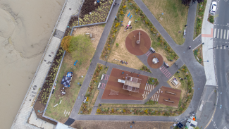
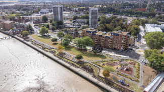
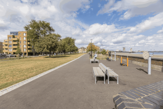
Riverside Gardens, Erith – Root and Erect
The existing park was redeveloped to address the connection with the River Thames which was severed by 1980s flood defences. The park levels were redesigned to reinstate this connection, whilst providing play features and spaces for gathering and enjoying the riverside views. The provision of rain gardens throughout the park provides a solution to water management whilst bolstering biodiversity in the park and surrounding area.
© London Borough of Bexley
Activating spaces to, and along, the waterfront
4.19 Where proposals seek to raise defences, preserving a visual and physical connection to the water is vital as these connections can positively impact people's mental and physical health and wellbeing. Similarly, where key views towards the river exist at a distance, for example at the end of an existing road, it is important to maintain these sightlines for wayfinding and legibility within the area.
4.20 Sections where the height of flood defences differ can provide opportunities for stepped or terraced structures that can integrate seating and spaces for recreation and leisure, which should be explored where appropriate.
4.21 Consideration for different users and how they will arrive at, and access, the water should be reflected in design proposals. Existing pedestrian and cyclist routes towards the site should be identified through the Character Appraisal and opportunities to enhance and/or supplement these routes, and access points along the water, should be explored during design development.
4.22 Applicants should demonstrate consideration for all users and their different needs when framing new views. For example, providing lower openings and seating options and viewing platforms to accommodate people who are different heights and/or have additional access requirements.
4.23 Flood defences should never become barriers that restrict movement and access to the watercourses or publicly accessible spaces, and evidence of how this has been achieved should be provided in the Design and Access Statement. Flood gates or other movable defences that may create weak points in flood defences should be avoided unless unavoidable. In which case, the nature, use and management of the site should facilitate sound operating procedures.
4.24 All proposals should meet the requirements of the Equality Act 2010 and must ensure physical accessibility for all people as required by London Plan Policy D3 Optimising site capacity through the design-led approach. Continuous, level access routes along the riverside should be provided and shallow ramps at a 1:20 maximum installed alongside any stepped access to ensure access for all. Tactile paving at level changes and handrails for steps and steep sections should be provided.
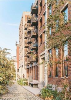
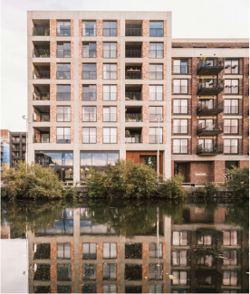
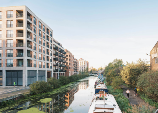
Neptune Wharf at Fish Island Village, Hackney Wick – Haworth Tompkins
Transforming a site of disused industrial warehouses, a collection of mid-rise residential buildings were introduced along the canal.
Buildings designed to reflect the industrial heritage of the place are punctuated with a series of public spaces, such as squares and courtyards, that front the canal, which was previously inaccessible. Planting and seating along new canalside walkways create public realm where people can take a moment to pause.
© Fred Haworth
Enhancing the appearance and quality of the water space
4.25 Bexley has distinct geology and the borough's watercourses contain rare ecological habitats that must be recognised, protected and enhanced. The Rivers Cray and Darent, for example, are two of few chalk streams in the world. Managing and protecting these waterbodies is vital to managing flood risk and maintaining waterways free from pollutants that can be damaging to both humans and wildlife.
4.26 Blue-green infrastructure should be designed into schemes to improve water quality by managing stormwater run-off, reducing pollution and preventing flooding. Infrastructure that can capture, store and recycle water, therefore reducing the amount of water needed during operation, should be prioritised. Such infrastructure can also have the benefit of enhancing the appearance of the water's edge.
4.27 Applicants should consider the infrastructure most appropriate for their development and its location and work with a specialist to integrate these into the proposal, providing details during pre-application stage and within reports submitted with a planning application. These can include:
- bioswales
- permeable paving
- tree trenches
- wet woodlands
- wetland scrapes
- urban forests and woodlands
4.28 The chosen blue-green infrastructure must not undermine the flood defences. Trees, for example, should be planted with sufficient space to ensure the roots will not impact the flood defences over time.
4.29 Where space allows, applicants should explore stepping back flood defences to allow the introduction of saltmarsh or wetland planting zones between the defence and water. Saltmarshes are natural flood buffers that slow water flow, support biodiversity and help to filter out pollutants. Raising saltmarshes can help avoid losing critical habitats to rising sea levels.
4.30 Along the Thames, applicants are encouraged to incorporate living shoreline interventions which can simultaneously create a habitat for wildlife and filter pollution from the water.
4.31 The integration of flood basins or wetlands that can also be used as recreational or educational spaces during dry periods should be considered where possible.
4.32 All proposals should be designed to minimise the need for ongoing maintenance, and with long-term maintenance in mind, and this must be demonstrated within the Maintenance and Management Plan. Applicants should work with the PLA, the EA, local environmental groups and community stakeholders to identify appropriate locations for habitat enhancements along flood defences.
4.33 Applications for land crossed by or abutting a watercourse must assess and demonstrate the potential for river restoration improving a river's environmental health by re-establishing its natural processes. This can include de-culverting or de-canalising and naturalising or semi-naturalising the channel.
4.34 Supported by the Development Plan, river restoration has the potential to increase river resilience and improve flood management whilst enhancing biodiversity and creating accessible river environments for recreation, boosting mental and physical health.
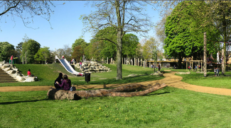
Wandle Park, Croydon – LDA Design
In the 1960s, to alleviate flooding issues that faced the park, the River Wandle was culverted and buried beneath playing fields in the park. Flood issues persisted, and a decline in park usage informed proposals to de-culvert the river to address this. Other improvements to the park such as a new play landscape, skate park, community gardens and cafe, have resulted in a public space for the local community to enjoy.
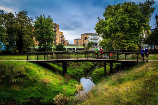
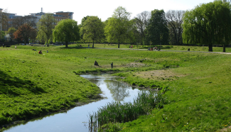
© LDA Design
4.35 Where development provides opportunities to undertake such works, applicants should refer to guidance and case studies prepared by the River Restoration Centre. The European Centre for River Restoration is another useful resource.
4.36 River restoration requires expertise and rigour and applicants should ensure that a suitably-qualified team is assembled from the outset.
Protecting and enhancing biodiversity
4.37 Applicants should prioritise on-site biodiversity improvements using suitable riverside planting, wetland creation, and green infrastructure. Planting locally appropriate, low-maintenance native species should be prioritised to ensure resilience and ecological value.
4.38 Where compliance with BNG is required, and where proposals may impact upon protected species or habitats such as nesting birds and bats, and/or where works are in or near SINC, applicants should undertake Ecology Assessments such as a Preliminary Ecological Appraisal (PEA) and an Ecological Impact Assessment (EcIA). Results should be presented to the Council during pre-application discussions and be used to inform design development that does not negatively impact the existing natural environment. Detailed guidance is set out in the Design Guide SPD Part 2 - Technical Handbook.
Promoting safety along the water's edge
4.39 The Port of London Authority (PLA) states that applicants must achieve compliance with Health and Safety at Work Act (1974), the Management of Health and Safety at Work Regulations (1999), the Occupiers Liability Act (1957) and the Occupiers Liability Act (1984) to ensure the safety of people engaging with the development.
4.40 It is recommended that a competent designer with experience in the marine environment and/or a marine risk and safety consultant forms part of the design team to carry out risk assessments and appropriately address this within the design proposal.
4.41 Flood defence structures should contribute to a safe, comfortable public realm. The design of barriers and railings should provide edge protection at all drop edges in line with building regulations and guidance from the EA. Applicants should employ site-specific approaches to preventing people from climbing over or through barriers and use a mixture of hard and soft edge boundaries such as parapets and fencing alongside landscaping and planting. The ongoing maintenance of this edge protection should be factored into the design.
4.42 Applicants should embed passive surveillance and overlooking into the design to avoid creating spaces where antisocial behaviour can thrive.
4.43 Proposals should demonstrate how the use, misuse and maintenance of public rescue equipment (PRE) will be managed, with applicants undertaking early engagement with the PLA, Local Planning Authority and other relevant stakeholders to understand the needs and requirements for new developments. PRE should be embedded into the design of the scheme, rather than implemented as an afterthought and should be installed alongside signage.
4.44 To ensure the safe rescue of individuals, the PLA recommends the provision and maintenance of the following equipment:
- life buoys and rings
- throw bags and lines
- ladders, steps and means of egress
- grab chains / hand holds
- vertical grab chains
- sloping revetment walls / tidal terracing
- bridge piers
4.45 Adequate lighting should be provided along routes near flood defences to promote safety after dark to eliminate unlit, secluded spaces along footpaths and enable people to identify riverside hazards such as steps and changes in level. An ecologically sensitive lighting strategy should be developed and presented to the Council during pre-application discussions and with a planning application.
4.46 Proposed lighting should ensure an even distribution of light with sufficient light levels for users, whilst avoiding excessive light pollution that can disturb wildlife. Directional lighting that reduces light spill within an ecological buffer zone and into the water, upward sky glow and glare is preferred. Lighting proposals should not have a negative effect on the safety of navigation.
4.47 Clear signage and maps should be located to assist navigation across and around flood defences. Signage should be minimal and avoid excessive coverage to maintain legibility. Signs should clearly indicate areas that must be kept clear of obstruction or that are used in emergencies, such as at flood gates or openings.
4.48 Signage should be appropriate for the location and need, whether instructional, directional, warning, prohibitive or supportive. Applicants should consider the use of pictorial signage with few words for non-native English speakers. Where text is used, it should be clear, concise and consistent both within the development site and in other areas along the water.
4.49 New developments are encouraged to include signage or plaques of the location of flood defences, raising public awareness of the infrastructure in place to protect people and developments from flood risks.
4.50 Applicants should refer to the PLA's Drowning Prevention Strategy that sets out the practical steps to be taken to improve waterside safety for those close to the river and includes guidance on appropriate suicide prevention measures, which can include signage integrated along waterways.
4.51 Signage should identify where a landowner is responsible for maintenance to the flood defences and that permission from the EA is needed prior to undertaking these works. Signage should be appropriately sized, with durable fixings, and located to avoid the proliferation of signage in any one place.
4.52 Applicants should refer to the TfL design standards that promote high quality and consistent communications and the Association of Inland Navigation Authorities' document Navigation Signs and Symbols: An industry standard for UK inland waterways for further guidance.
4.53 To supplement the signage implemented within a scheme, developers are strongly encouraged to provide education and training programmes from the emergency services to equip those enjoying the river and residents moving into new developments with adequate water safety education and practical skills such as throw line training.
4.54 Educational signage should also be considered near ecological buffer zones and habitats near main rivers to enhance the public's connection to the rivers and the wildlife and ecosystems they contain.
A 13 Development within the Thames Policy Area should enhance people's experience of the place
Bexley Local Plan Policy DP19 The River Thames and the Thames Policy Area refers to the Thames Policy Area (TPA) defined on the Bexley Local Plan Policies Map and the need for development proposals in these locations to integrate ecological and habitat enhancements, improve access to nature within the TPA and consider the development's potential impact on the ecology of the River Thames, its priority habitats and protected species. The Policy advocates for improved access to nature and the creation and enhancement of habitats.
4.55 Bexley's sections of the Thames Path run for ten miles and pass through Thamesmead, Erith and onwards to Crayford Marshes and Crayford Ness to the east of the borough. The character of these sections varies as the townscape changes from more residential and industrial at Thamesmead towards Crayford Marshes' marshland that is rich with wildlife and nature.
4.56 Bexley's stretch of the Thames Path is well served by public transport, presenting a opportunity to both encourage active travel and welcome visitors from further afield. The Port of London Authority's Tidal Thames Masterplan has designated Bexley as the first borough for strategic enhancement, with proposals to maximise the use of the borough's safeguarded wharves, promote riverside sporting facilities and highlight the ecological and environmental benefits of the Tidal Thames and other local watercourses.
4.57 Given the recreational value of the Thames Path and its importance as a walking and cycling route, some areas of the route present opportunities for improvements to enhance character. Proposed improvements should create a welcoming, resilient and inspiring riverside environment for current and future generations to enjoy. Works should blend high quality public realm design with a robust flood management proposal that follows the design principles outlined in A 12.
4.58 Applicants should prioritise early and ongoing engagement with local stakeholders and visitors, particularly those who frequent the area, who can provide knowledge and insights into how the area is used and where improvements could be made. Using guidance set out in D 06 of the Design Guide SPD Part 1 - Design Principles, applicants should demonstrate how a consultation strategy has been mapped out for the duration of the project and demonstrate evidence of how consultation and engagement has been used to develop proposals.
Public realm enhancements
4.59 Proposals should respect and reinforce the unique character of the riverside setting. Applicants should undertake a Character Appraisal to understand the current and historic characteristics of their development site and its surroundings.
4.60 Enhancements proposed along the Thames Path present opportunities to provide spaces that support the mental and physical health and wellbeing of Bexley's residents and visitors through the provision of green space, areas for sports and leisure activities and spaces for people to gather and meet.
4.61 Applicants should, where practical, introduce seating and lighting to provide areas of rest at regular intervals. Interpretation boards could be incorporated to raise awareness and interest in the site's history, and more widely regarding ecology and climate change adaptation.
Pier Square, Erith – BDP
At the entrance to Erith Pier, public realm enhancements were undertaken to provide a community space for gathering and events. The square also provides those walking the Thames Path a place to pause and sit whilst overlooking the River Thames. A range of seating options are provided to accommodate a range of visitors and lighting enhances the space. Robust species are planted to withstand the strong winds common in the area and visually enhance the space and local biodiversity.
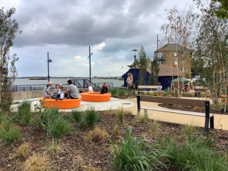
© London Borough of Bexley
4.62 The visual enhancement of the Thames Path should be considered through proposals for new public art that can also shape the identity of the place. Applicants should explore opportunities for community-led design to evolve art, heritage markers and visual identities that reflect the local character. Realising public art projects with local artists and groups is strongly encouraged and will be looked upon favourably by the Council.
4.63 Applicants should integrate appropriate wayfinding around the site and to provide connections to areas further inland near the Path. This can also be used to provide information about rich local heritage and history of the Thames Policy Area. Directional signage should also be considered to alert people to distances to key landmarks, public transport connections and cycle networks within the local area.
Conserving and enhancing existing, and creating new, habitats and ecology
4.64 At the outset of design development, applicants should undertake surveys to identify key existing habitats such as reedbeds, mudflats, saltmarshes and veteran trees. These baseline surveys should be used to identify the presence of protected species such as water voles and bats and invasive species like Japanese knotweed, giant hogweed and Himalayan balsam.
4.65 Where invasive species are found, applicants should develop a control strategy for these and where required by law, engage a licensed contractor to remove them. Applicants are also encouraged to report invasive non-native species (INNS) to the GB Non-Native Species Secretariat.
4.66 When proposing ecological enhancements, applicants should prioritise the reinstatement or supplementation of native riparian vegetation, particularly:
- marginal species i.e. reeds and sedges
- native grasses and wildflowers that are pollinator friendly
- hedgerows and trees such as alder, willow and hawthorn
4.67 Species selection, establishment conditions and ongoing management requirements must all be considered to ensure long-term maintenance beyond the year of planting, for example by avoiding species with a high water demand that requires frequent irrigation, and highly flammable species.
4.68 Non-native ornamental species should be avoided, particularly within ecological areas. Where near-native and non-native species are considered to demonstrate greater climate resilience, ecology function and long-term viability compared to a purely native palette, applicants must provide evidence and justification for their use.
4.69 Near-natives and non-native species should only ever be used to supplement and complement a native-led planting palette, not replace it entirely. The Council will not support landscape schemes that consist of predominantly of non-native ornamental species where native or near-native alternatives could be accommodated.
4.70 When creating new habitats, priority should be given to:
- floating and other wetlands, that enhance aquatic habitat without compromising flood defences
- wildflower meadows, to replace or supplement mown verges and increase biodiversity
- hibernacula, providing log piles, stone stacks and bug hotels
- artificial nesting features such as bat and bird bricks such as swift bricks
- ponds and scrapes, introducing seasonal wetland features where appropriate and space allows
- living river walls, useful where space is at a premium in supporting algal and invertebrate wildlife
4.71 Landscape proposals must be designed for projected climate conditions over the lifetime of a development, rather than solely for present day conditions. The long-term viability of proposed planting should be demonstrated, taking account of anticipated changes in temperature, rainfall patterns, summer drought frequency and urban heat island effects.
4.72 Habitats should not be created in isolation and applicants should seek opportunities to create links with existing and proposed wildlife corridors using green infrastructure such as hedgerows, ditches and treelines. The Thames Path Area boasts several existing wildlife corridors including the Ridgeway Link, Thamesmead Link, Thames Marshes corridor, and the River Thames. Applicants should demonstrate how their proposals make use of, and contribute to, these existing wildlife routes.
4.73 New planting along the Thames Path should ensure sightlines are maintained and avoid hidden and enclosed areas that can contribute to antisocial behaviour. The ongoing maintenance of vegetation and planting will be essential to ensuring people can use the Path in safety throughout the year. Applicants must consider an appropriate maintenance strategy when developing proposals, evidencing this during pre-application discussions and within planning submissions.
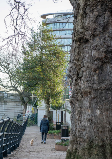
Waterman's Green, Putney – Project Centre
Through engagement with local stakeholders, a largely inaccessible, narrow stretch of land running alongside the River Thames has been transformed into a pocket park that offers a chance to pause and enjoy views of the river. The new park also create a green corridor for wildlife to thrive, using native trees and diverse planting to restore previously lost vegetation and habitats to improve local biodiversity and ecology.
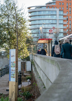

© Project Centre
Improving access to, and understanding of, nature
4.74 The ecology, habitats and wildlife found within the Thames Policy Area are unique and present opportunities for improved knowledge of these ecosystems. Applicants should seek to enhance and encourage public understanding of the importance of this natural environment through their proposal.
4.75 Where appropriate, built structures such as bird observation hides and visitor centres alongside habitat enhancements can support public learning about these habitats without disturbing the wildlife. Proposals should, where possible, be co-designed with the community to encourage community stewardship following completion, empowering residents to actively protect their built environment.
Permissions and consent
4.76 Depending on the proposed extent, nature and location of works along the Thames Path, in addition to seeking planning permission from the Local Planning Authority, applicants should engage other relevant stakeholders to understand the required permissions.
4.77 Fig. 24 outlines these stakeholders and likely permissions, and applicants should engage early with each relevant party to understand the requirements for individual their scheme.
4.78 Where proposals interact with Cycleway networks, applicants may need to seek permission from TfL, and Network Rail should be consulted where development is proposed near rail infrastructure.
Figure 24
Fig.24 Consents which may be required for development
| Consent type | Consent required from | When required |
|---|---|---|
| Planning permission | Local Planning Authority (LPA) | Most physical improvements i.e. any significant construction, resurfacing, lighting, new/replacement signage, proposed changes to public access |
| Flood Risk Activity Permit | Environment Agency (EA) | Works within 16m from landward extent of tidal defences including any buried elements and within 8m from the top of riverbank of fluvial main rivers, such as digging, piling or foundations; surface changes or structures within the setback zone; discharge of surface water or creation of outfalls |
| Marine Licence | Marine Management Organisation (MMO) | Works below the high tide mark i.e. new pontoons, steps or structures into the river or foreshore |
| River Works Licence | Port of London Authority (PLA) | Works affecting the riverbed or foreshore |
| Landowner Consent | The Council / PLA | All works on public of PLA-owned land |
| Listed Building Consent | LPA | Works affecting listed heritage structures such as bridges, historic river walls or embankment features |
| Rights of Way/Highway Consent | Highway Authority | Modifications to the public path that include temporarily closing, diverting or modifying the path |
Construction
4.79 A phased construction should be planned to maintain path usability where possible, with on-site notices and digital updates providing ongoing updates to the public. Details must be provided within a Construction Management Plan submitted with a planning application.
4.80 Proposals should take account of protected habitats and species, and the mitigation measures required where these are found. For example, developers should time construction to avoid disturbing protected habitats and species by planning works outside the bird nesting seasons, typically March – August.
4.81 Buffer zones should be used to prevent damaging and polluting existing habitats, with applicants using pollution control measures like sediment fences and silt traps.