
5. Drainage and Flood Risk
Policy context
London Plan Policy SI 13 Sustainable Drainage sets out the Mayor's aim for managing surface water for new development. It sets out the well-established drainage hierarchy that helps to reduce the rate and volume of surface water run-off. This hierarchy aims to manage surface water in the most sustainable way, encouraging water reuse on site and reducing the amount of surface water to be discharged off-site. Applying the hierarchy will lead to more sustainable water management and reduce the burden on the capacity of sewers within the borough.
Bexley Local Plan Policy DP33 Sustainable drainage systems sets out clear requirements regarding how new development in the borough should manage surface water drainage and requires that all development manage surface water using sustainable drainage systems. Policy DP32 Flood risk management makes it clear that flood risk must be managed to not cause an increase in flood risk both on and off site.
The DEFRA Non-Statutory Technical Standards for Sustainable Drainage Systems (2015) defines the minimum performance standard for runoff destinations, flow control, and storage requirements. The LLFA expects that developments will exceed these minimum standards wherever feasible.
General guidance
Sustainable drainage systems (SuDS), implemented correctly, have the potential to provide multiple benefits, both directly to new development and to the wider area.
If considered at an early stage of the development, SuDS can be incorporated to provide effective surface water management and wider amenity value by creating green spaces throughout the development. Applicants should consider how SuDS can be incorporated into their design to provide the maximum benefits.
The Council's Sustainable Drainage Design and Evaluation Guidance document provides clear guidance on the implementation of SuDS to ensure that proposals meet agreed standards and are maintainable now and in the future.
Integration with urban design and green infrastructure
4.1 Applicants should consider SuDS at the earliest stages of design of the development as this will increase their effectiveness and can provide wider amenity value to development.
4.2 Effective SuDS design can offer multifunctional benefits, such as:
- a. Enhanced public realm and visual amenity
- b. Biodiversity and habitat creation, which could contribute to Biodiversity Net Gain (BNG) requirements
- c. Urban cooling and climate adaptation
- d. Improved air and water quality.
4.3 To maximise the full potential, a sustainable drainage system should be thought of as a series of sequential components, rather than a single standalone solution – known as the 'management train' approach.
4.4 Different components will have different, although sometimes overlapping, functions that together deliver the required performance for water quantity, quality and the wider biodiversity benefits. Considering SuDS early on in the design process and incorporating different measures will help maximise the full benefits that they can offer.
Figure 49
Fig.49 Principles of SuDS design
| Design principle | Purpose |
|---|---|
| Water quantity | Control the rate and volume of runoff to reduce flood risk and preserve the natural water cycle. |
| Water quality | Manage the quality of runoff to prevent pollution. |
| Biodiversity | Create and sustain better places for nature. |
| Amenity | Create and sustain better places for people. |
Source: Bexley Sustainable Drainage Design and Evaluation Guide.
Requirements for new development
4.5 All development proposals, whether increasing or decreasing the impermeable area of the site, are required to manage surface water through SuDS.
4.6 All development proposals must demonstrate that:
- a. The drainage for the site achieves greenfield run-off rates for all flood events up to and including 1 in 100 years plus 40% climate change
- b. Surface water run-off has been reduced by sustainably managing run-off on site
- c. Permeable paving has been used for hardstanding areas
- d. The nature of water flow (both surface water and groundwater) across a steeply sloping site has been considered in order to provide suitable SuDS, and
- e. Water reuse mechanisms have been included for either indoor or outdoor purposes.
4.7 New surface water connections to a foul sewer will not be permitted, as this is the major contributor to sewer flooding. Any existing surface water connections to a foul sewer must be removed and alternative suitable surface water drainage must be created.
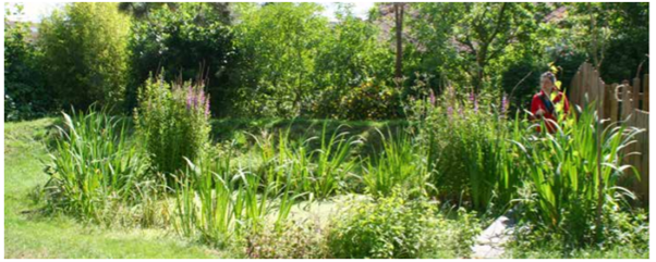
Fort Royal Primary School, Worcestershire
A wetland was introduced into a school grounds to enhance biodiversity and create new habitats that contribute to the wider green infrastructure network in the local area.
© McCloy Consulting & Robert Bray Associates
Drainage hierarchy
4.8 All new developments must show that they have followed the drainage hierarchy, providing significant consideration for each option.
4.9 London Plan Policy SI13 sets out the well-established drainage hierarchy as shown in Fig.50. The drainage hierarchy sets out a prioritised sequence for discharging surface water from developments, with the aim of mimicking natural drainage as close as possible.
4.10 The drainage hierarchy should be considered as early as possible and throughout the development design process to maximise their effectiveness and increase opportunities for water reuse and storage across the site.
4.11 The drainage hierarchy in order of preference:
- Rainwater use as a resource – capturing rainwater on site through rainwater harvesting systems, such as blue roofs and water butts, for reuse on site.
- Infiltration to ground – where ground conditions allow, rainwater can be captured on site and released to ground, mimicking natural processes, through the use of soakaways and other infiltration methods.
- Rainwater attenuation in green infrastructure – the use of SuDS, such as swales, basins, green roofs and wetlands, to store and slowly release water. Green infrastructure presents a great opportunity to deliver wider environmental benefits, including contributing to biodiversity net gain, and creating greater amenity value to new development.
- Controlled discharge to a surface water sewer – This option should only be considered once all the previous steps have been proven to be unviable. If selected, it must be shown that discharge rates will be reduced to greenfield runoff rates for all flood events up to and including 1 in 100 years plus 40% climate change.
- Controlled discharge to a combined sewer – This is the least preferred option and will only be accepted once all previous steps have been proven unviable. The sewer must be officially designated as a combined sewer and it must be shown that discharge rates will be reduced to greenfield runoff rates for all flood events up to and including 1 in 100 years plus 40% climate change.
4.12 Surface water connection to a foul sewer is not within the drainage hierarchy and will not be permitted.
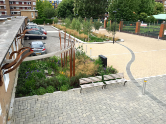
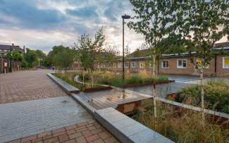
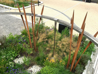
Bridget Joyce Square, White City – Robert Bray Associates
The project sought to create a better space for the community and a landscape that manages rainwater using SuDS. Rainwater is captured at roof level from the nearby school and directed into the SuDS landscaping using rainchains secured within raingardens. Permeable paving is used to allow rainwater to pass through the surface and is supported by street trees, raingardens and landscaped basins.
© Robert Bray Associates
Figure 50
Fig.50 – The drainage hierarchy
| Priority | Description |
|---|---|
| 1. Rainwater use as a resource | e.g. rainwater harvesting and blue roofs |
| 2. Rainwater infiltration to ground | Allow rainwater to infiltrate naturally into the ground where suitable |
| 3. Rainwater attenuation | Store rainwater within green infrastructure for gradual release |
| 4. Rainwater discharge direct to a watercourse | Discharge rainwater directly to an appropriate watercourse |
| 5. Controlled rainwater discharge to a surface water sewer | Discharge at a controlled rate to a surface water sewer |
| 6. Controlled rainwater discharge to a combined sewer | Discharge at a controlled rate to a combined sewer as the least preferred option |
Surface water drainage strategy
4.13 All development proposals on sites of 0.25 hectares or greater require a drainage strategy, which must be accompanied by a suitable maintenance and management plan. This is in addition to a site-specific Flood Risk Assessment (FRA), which is required for all proposals within Flood Zone 2 and 3 and all proposals on sites of 0.25 hectares or greater.
4.14 A site-specific surface water drainage strategy should include:
- existing and proposed drainage plans
- greenfield runoff rate calculations
- details of storage volumes and discharge locations
- details and justification of SuDS components
- a maintenance and management plan.
Full details of what should be included in the drainage strategy can be found in Fig.51.
Figure 51
Fig.51 - Required contents for a drainage strategy
| Component | Description |
|---|---|
| Site overview | Location, topography, flood risk context (including Critical Drainage Areas and surface water mapping) |
| Pre- and post-development runoff rates and volumes | Quantify existing and proposed runoff regimes, including changes in impermeable area |
| SuDS design | Proposed sustainable drainage features (e.g. swales, basins, permeable paving), their function and location |
| Drainage layout plan | Plan showing pipe network, SuDS features, flow paths, and discharge locations |
| Exceedance flow routes | Diagram and explanation of how flows are managed in extreme events or system failure |
| Discharge point | Justification and evidence of hierarchy compliance, e.g. infiltration testing, Thames Water agreement |
| Storage volumes | Calculations for all rainfall events up to 1 in 100-year + climate change, showing how storage will be provided |
| Discharge rates | Calculations for all rainfall events up to 1 in 100-year + climate change, showing the proposed discharge rates |
| Maintenance plan | Details of who will own, inspect, and maintain the system, including long-term funding arrangements |
Drainage calculations
4.15 Planning applications must be supported by drainage calculations to demonstrate that the proposed development will not increase flood risk and complies with national, regional and local policy.
4.16 Applications should follow the revitalised Flood Estimation Handbook (FEH) statistical method to estimate greenfield runoff rates. The IH24 method is considered acceptable for smaller, single dwelling sites, as it has been designed for small catchments.
4.17 The rates must be based on site-specific characteristics, including:
- soil type and infiltration capacity
- topography and catchment area
- proportion of impermeable area post-development.
4.18 Drainage calculations must be submitted for the proposed drainage strategy to demonstrate how the system performs for all return periods and is compliant with all relevant policies.
Figure 52
Fig.52 Example surface water drainage plan
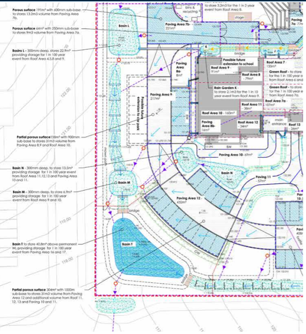
Source: Bexley Sustainable Drainage Design & Evaluation Guide
Managing exceedance flow
4.19 In addition to demonstrating that on site drainage can manage surface water for all return periods, including the 1 in 100 year plus 40% climate change allowance, drainage systems must also account for events that exceed the design capacity, known as exceedance flows.
4.20 Exceedance routes must be:
- directed away from the most vulnerable elements of the development
- designed to avoid property flooding
- safely routed through landscaping, open spaces and road
4.21 The design of finished site levels is a critical aspect of exceedance planning. Ground levels should direct water away from entrances and sensitive areas, particularly in areas of known flood risk.
4.22 Any planning application must be accompanied with an exceedance flow plan that clearly demonstrates the exceedance flow routes. Site levels should be included on these drawings to show the site topography and help show the flow routes.
4.23 Exceedance flows should be managed on site where possible, being directed to green spaces and open areas of land. If they need to be directed offsite, this must be away from neighbouring buildings and should be into open spaces.
Figure 53
Fig.53 – Example exceedance flow diagram
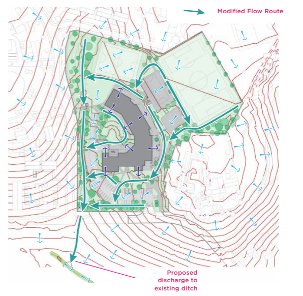
Example exceedance flow diagram. Bexley Sustainable Drainage Design & Evaluation Guide
Maintenance and adoption of surface water drainage systems
4.24 Surface water drainage systems must be designed with long-term performance, resilience, and maintenance in mind. Without appropriate maintenance, systems can fail, resulting in flood risk, water quality degradation, and costly remedial works.
4.25 Both the London Plan (Policy SI13) and the Bexley Local Plan require developers to provide robust arrangements for the ongoing maintenance and management of surface water systems.
General maintenance principles
4.26 All drainage systems should be designed to be durable, accessible, and easy to maintain and maintenance should be considered from the earliest stages of design, not post-construction.
4.27 SuDS components should favour simple, robust, and surface-based systems, which are easier and cheaper to maintain than buried infrastructure.
4.28 Systems should be designed with minimum reliance on proprietary systems that require specialist maintenance contracts, unless justified.
Operation and maintenance requirements
4.29 An Operation and Maintenance Plan must be included for all developments on sites of 0.25 hectares or more, and set out in accordance with Fig.54.
4.30 The Operation and Maintenance Plan must be proportionate to the scale of the development, detailed and practical.
Adoption of drainage systems
4.31 Developers must confirm the long-term ownership and adoption arrangements for the drainage system.
4.32 Any proposed surface water pump that serves more than one property will need to be adopted by Thames Water. The applicant should submit evidence of this to the LLFA with a planning application.
Figure 54
Fig.54 - Required contents for an Operation and Maintenance Plan
| Component | Description |
|---|---|
| Maintenance schedule | Routine, occasional, and remedial tasks listed per asset (e.g. monthly litter clearance, annual vegetation management, inspection of inlets and outlets) |
| Access arrangements | Clear explanation of how all drainage features can be accessed and safely maintained |
| Responsibility and ownership | Details of the organisation or body responsible for the long-term maintenance of each part of the system |