
3. Highways and Transport
Policy context
Compliance with the Bexley Local Plan and the local transport policies set out in Bexley's Local Implementation Plan is integral to the Council's approach to assessing the likely impact of developments on the transport network, including ensuring that new schemes and re-developments meet Bexley's current and future needs. In some cases, local needs mean criteria and thresholds differ from those accepted elsewhere in London.
Bexley Local Plan Policy DP22 Sustainable transport details the Council's support for the alternatives to traditional car parking such as the use of Electric Vehicle Charging Points (EVCPs) and car clubs. This should be read alongside Policy SP10 Bexley's transport network, which encourages a transitional approach to providing car parking in new developments and notes parking layouts should be flexible.
Policies DP23 and DP24 set out the Council's approach to parking management and the impact of new development on the transport network. The latter covers the Council's procedures for alterations to the highway network to mitigate the effect of development traffic, as well as the 'Monitor & Manage' process to confirm whether highway works, based on predictions in the Transport Assessment, proved to be correct or not.
London Plan Policy T6 Car parking sets the framework for assessing parking provision in planning proposals.
Guidance provided in this chapter should be read in conjunction with the Public Realm section of the Design Guide SPD Part 1 - Design Principles, in particular the Movement chapter.
General guidance
The Council is the Highway, Traffic and Street Authorities for all roads in the borough apart from the Transport for London Road Network (TLRN), which in Bexley is the A2 and A20.
Any works or alterations to the highway require permissions from the Highway Authority, which are separate to the planning process.
These separate permissions prior to works in the highway include road opening notices for trial holes etc. and permits for utility connections to a new development (under the New Roads & Street Works Act 1991). These are in addition to the agreements for alterations to the highway (under the Highways Act 1980) and any necessary Orders to control traffic or stop-up sections of the highway (both of which are subject to separate public consultation and possible objection).
The timing of works under notices and permits is dependent on a number of factors, including other scheduled or emergency works in the highway in the vicinity of the site, which may mean than a developer's planned programme is delayed as a result.
The Council is committed to the approach set out in the national guidance, Manual for Streets (MfS), including MfS 2 and 3. This guidance sets out local standards and criteria for streets and their maintenance against specific elements of MfS and the documents should be considered in conjunction.
Prior to formal pre-application discussions, the Highway Authority can provide initial guidance on the scope of highway and transport information required for the pre-application process. The team can also provide guidance on non-planning processes and likely required approvals. To obtain initial highway and transport advice, applicants should contact the Highway Authority at: transport&development@bexley.gov.uk
For pre-application meetings arranged without initial guidance sought from the Highway Authority, and to ensure productive pre-application meetings, applicants should prepare data and proposed analysis techniques on traffic generation, servicing, access arrangements and parking. This is usually best clarified through an initial scoping report on transport-related issues, which should include any need for modelling, ongoing management plans or future mitigation works.
Further information on the Council's fees for development-related highway approvals, and likely order of magnitude costs for future impact of the development scheme, can be sought from the Highway Authority.
Transport Assessments & Statements
2.1 Developers must submit an evaluation of the travel implications of their proposals, which will form part of the Council's considerations of the development. This will need to set out the expected impact of the development on the highway and transport networks during demolition and/or construction and when completed, with full justification and to a scope agreed with the Highway Authority.
2.2 Where appropriate, this will need to be accompanied by obligations for future monitoring, to ensure that measures agreed at the time permission was granted has proved to be sufficient. These measures can include the impact of the development on the highway network and required future mitigation, or the success of travel plans and provision of additional measures for active travel in the future, achieving mode of travel targets agreed under the planning consent.
2.3 This supporting justification can vary from a Transport Statement (TS) for smaller and more basic schemes, to a Transport Assessment (TA) for larger or more complex schemes, or proposals in areas where the transport network is more sensitive. Fig.12 sets out the information to be included in these documents.
Thresholds and criteria
2.4 Appraisals should set out the existing transport infrastructure and the current traffic situation, as well as predicting the effects of the proposed development.
2.5 The scope and thresholds of the appraisals are generally the same as those advocated by Transport for London (TfL), however the Council has some local thresholds.
2.6 Developers should use the thresholds listed in Fig.12, based on the size or scale of the proposed land uses.
2.7 Not all planning applications require a transport appraisal; however the Council may ask for one to be submitted even if the development proposal does not appear in the list in Fig.12. This may be due to the cumulative effect of several uses below the individual threshold for each in a mixed-use scheme, traffic generation characteristics, or in areas where the transport network is more sensitive (such as in a Controlled Parking Zone (CPZ)).
2.8 Traffic generation characteristics may, on their own, require a TA, even if the spatial thresholds are not met, and these developments are also listed in the TfL Transport Assessment guidance. These characteristics, as well as those related to the period over which a development may be delivered, are outlined in Fig.13.
Scope of assessments and considerations
2.9 Fig.14 is a general guide only and applicants should determine the full scope with the Highway Authority as early in the planning process as possible.
2.10 The contents should demonstrate a prioritisation for active travel, looking first at walking then cycling and public transport trips, rather than focusing on car trips.
Survey Methodologies
Traffic surveys
2.11 Surveys to identify the existing performance of the highway network, in terms of junction capacity, queues and journey times, will be required as part of the Transport Assessment (and possibly a Transport Statement). The scope of these surveys should be agreed with the Highway Authority, to ensure that the number and timings of surveys produces the most representative data to reflect actual conditions.
2.12 Guidance for developers who wish to arrange and undertake their own surveys, either direct or through specialist consultants/contractors is available from the Highway Authority.
2.13 The Council also carries out its own surveys, which can be made available for a fee. Details of the data available, and the likely cost, can be obtained by contacting the Highway Authority.
2.14 The Bexley Local Plan is supported by strategic traffic models and where appropriate developer's submissions should be consistent with and informed by the outputs from these. The Council may be able to make this modelling available for a fee.
Parking surveys
2.15 Developments should avoid contributing to an increase in on-street parking, particularly where this would be detrimental to amenity, traffic flow or road safety.
2.16 Where this may arise, Parking Capacity Surveys should be submitted as part of the application. As with all surveys, data should be collected at the times agreed in the Highway Authority scope and over a minimum of two days to ensure results are consistent and representative. This should provide an accurate picture of existing on-street parking availability and any spare capacity, so an informed decision can be taken on the likely impacts of the proposal. This means that only areas where parking would be acceptable should be included in the surveys.
2.17 The survey methodology recommended in the 2021 Lambeth Council Parking Survey Guidance Note is generally acceptable when undertaking surveys, provided the local amendments outlined in Fig.15 are incorporated.
2.18 Conducting the surveys to suit the local context is vital and therefore should ensure that the length of assumed parking spaces is suitable for the Bexley context, using a 5.5m module, rather than 5m as in Lambeth. Surveys should be undertaken at appropriate times and dates to record representative variations in parking demand throughout the day as well as the peak parking demand of the proposed use (e.g. shift changeovers for commercial developments or healthcare-related uses).
2.19 If a development occurs in an area where a Controlled Parking Zone (CPZ) or Restricted Parking Zone (RPZ) system operates, the LPA may require that future occupiers are not eligible to acquire permits to park in the Zone to reinforce travel by sustainable modes.
2.20 Any alteration to Traffic Management Orders relating to on-street restrictions and the associated signs and lines, including those controlling a CPZ or RPZ, will only be carried out at the applicants' expense.
2.21 For car-free or car-lite developments, it must be evident in the application how this arrangement will not create overspill parking onto existing streets, as well as what initiatives will be included in the Travel Plan to encourage active travel and discourage car ownership and use.
Transport Assessment Conclusions and 'Monitor & Manage'
2.22 The TA or TS should provide a robust appraisal of the likely impact of the development on the road network and public transport services, including trip rates/assignment to the local highway network and modelling the impact on the operation/queuing at junctions.
2.23 This should be carried out in accordance with the scope agreed with the Highway Authority and will normally include junction modelling. Applicants should use approved software packages and calibrated ensure calibration with actual queue length surveys, following the TfL Traffic Modelling Guidelines and criteria in the Department for Transport Design Manual for Roads and Bridges (DMRB).
2.24 Whilst service enhancements to mitigate impacts on public transport services may be dealt with by financial contributions for the operators, potential impacts on the road network is likely to include highway alterations in addition to those associated with the access to the development itself.
2.25 Depending on the period over which a development is likely to be delivered, especially if delivery is likely to be phased, and the nature of the alterations proposed, or the sensitivity of the operation of the network in that location, the Council may require a 'Monitor & Manage' protocol to any planning permission, pursuant to Bexley Local Plan Policy SP10 Bexley's transport network and paragraphs 6.27 and 6.28 in the policy implementation text.
2.26 This protocol will set out a methodology for future surveys and monitoring after the development is occupied at pre-determined levels to confirm whether the predictions in the TA, and any resultant highway mitigation works, were adequate.
2.27 It will also identify apposite trigger points for agreed interventions when they have been reached, and if not what further mitigation might be required. The results of the future study will inform the nature of any further mitigation measures necessary and determine apposite developer contributions and other funding sources.
2.28 Any off-site highway works may be carried out by the developer under a S278 agreement or, depending on the sensitivity of the highway concerned, by the Council itself.
Active Travel Zone (ATZ) Assessments
2.29 An Active Travel Zone (ATZ) Assessment is a tool used to appraise the accessibility of a site and its surroundings to sustainable modes of travel and can be a standalone document or included in a Travel Plan or as part of a Transport Assessment.
2.30 An ATZ Assessment evaluates the quality, safety and accessibility of walking and cycle routes between a proposed development and key local destinations, such as:
- public transport stops and stations
- current and future cycle networks
- town centres and shopping areas
- local employment districts
- local schools, colleges and hospitals
- parks and green/blue spaces
- places of worship
2.31 As well as identifying existing connections, the assessment should identify suitable improvements that could be provided through the development to ensure that it facilitates sustainable travel, thereby improving health outcomes and reducing car dependency.
2.32 The assessment should also cover how possible additional measures or improvements identified through future monitoring can be funded and delivered.
2.33 Further detailed advice and guidance is available through TfL; however, the scope of the ATZ and associated methodology should be discussed with the Highway Authority in advance of completion.
2.34 The scope and methodology of an ATZ will typically follow the steps outlined in Fig.16.
Figure 12
Fig.12 Local Bexley Transport Statement / Transport Assessment spatial thresholds (based on proposed land use)
| Class Use | Transport Statement | Transport Assessment |
|---|---|---|
| Class E – Commerical, business and service | 1000 - 2500m² GFA* | >2500m² GFA |
| Class F.1 – Learning and non-residential institutions | Highway Authority request | Highway Authority request |
| Class F.2 – Local community | Highway Authority request | Highway Authority request |
| Class B2 – General industrial | 1000 - 2500m² GFA | >2500m² GFA |
| Class B8 – Storage and distribution | 1000 - 2500m² GFA | >2500m² GFA |
| Class C1 – Hotels | Highway Authority request | >100 bedrooms |
| Class C2 – Residential institutions | Highway Authority request | Highway Authority request |
| Class C2A – Secure residential institutions | Highway Authority request | Highway Authority request |
| Class C3 – Dwellinghouses | 10-50 units | >50 units |
| Class C4 – Houses in Multiple Occupation (HMOs) | Highway Authority request | Highway Authority request |
| Sui generis – Food retail | 250-800m² GFA | ≥800m² GFA |
| Sui generis – Non-food retail | 800-1000m² GFA | ≥1000m² GFA |
| Sui generis – Restaurants & cafes | 250-2500m² GFA | ≥2500m² GFA |
| Sui generis – Drinking establishments | 250-600m² GFA | ≥600m² GFA |
| Sui generis – Hot food takeaways | 250-500m² GFA | ≥500m² GFA |
| Sui generis – Assembly and leisure | Highway Authority request | Highway Authority request |
Figure 13
Fig.13 Developments that will require a TA where spatial thresholds are not met are those:
- not in conformity with the adopted development plan
- that generate >30 two-way vehicle movements in any hour
- proposing 100 or more car parking spaces;
- which may increase accidents or conflicts among motorised users and non-motorised (particularly vulnerable) users
- generating significant freight or HGV movements per day, or significant abnormal loads per year
- in a sensitive location on the network or with inadequate transport infrastructure, including substandard roads, poor pedestrian/cyclist infrastructure or inadequate public transport provision
- those that are likely to be delivered in phases over several years
Figure 14
Fig.14 Areas that would typically be covered in a TA or TS include:
- an introduction and baseline conditions for site, local area, and wider network (including public transport connectivity and opportunities for active travel, as well as the highway network)
- trip generation for all modes, existing and future, including construction traffic and potential parking issues
- likely impacts at the site, local area and wider network, including cumulative and total impacts
- mitigation and opportunities to support local transport goals
- frameworks or the scope of Construction Management Plans, Travel Plans, Car Parking Management Plans and Delivery & Servicing Plans
- suggested 'monitor & manage' protocols to ensure future traffic impacts are the same as predicted at the time planning permission was granted and whether further mitigation could be delivered if required
Figure 15
Fig.15 Parking Capacity Survey methodology for surveys undertaken in Bexley
- the timing of surveys and areas to be surveyed should be agreed in advance with the Highway Authority, to ensure they are at the time of day when parking will be most critical for the development as well as the surrounding area
- where no restrictions are present on a road 3 metres width should be assumed as the minimum clear vehicle path when establishing where vehicles can and cannot park (to ensure sufficient room for HGVs and emergency vehicles to be able to safely pass etc.)
- the results should be presented in both a graphic and tabular form
- a plan, preferably at 1:1250, should be provided indicating the location of the available parking spaces (the plan should include details of waiting restrictions and vehicle crossings over footways etc.)
- the number of cars parked on each road within the survey area on each night must be counted and recorded, and the location of each car should be noted approximately on the plan (marked with an 'X')
- photographs should be taken of the parking conditions in the survey area to support the results
- when calculating potential parking capacity, it should be assumed that each vehicle space measures 5.5m in length (rather than 5m as set out in the Lambeth methodology)
Figure 16
Fig.16 ATZ Assessment scope and methodology
1 Defining the ATZ Scope
- mapping the site's 20 minute walking and cycling zones
- identifying key active travel destinations within the ATZ
2 Prioritising Destinations
- High priority destinations:
- public transport nodes;
- strategic cycle networks;
- town centres and shopping areas; and
- employment districts
- Medium/low priority destinations:
- green spaces;
- schools; and
- medical centres
3 On-site Analysis and Photographic Surveys
- Day and night time site visits to assess routes using Healthy Streets Indicators, with (Point of View) photographs at appropriate intervals such as:
- easy to cross;
- people feel safe;
- not too noisy;
- places to stop and rest; and
- shade and shelter
- identifying hazards, deficiencies, or severance points impacting active travel
4 Vision Zero Analysis
- mapping clusters of collisions resulting in deaths or serious injuries (KSIs) along key routes
- proposing measures to improve safety and reduce vehicle dominance
5 Healthy Neighbourhood Characteristics
- assessing street density, permeability and proximity to green spaces
- identifying opportunities for improvements in public realm and active travel infrastructure
6 Recommendations and Mitigation/Improvement Measures
- Prioritised improvements, such as:
- new or improved pedestrian and cycle crossings;
- footway widening;
- resurfacing;
- hazard removal, protected cycle lanes and segregated routes; and
- enhanced wayfinding, lighting and safety measures
Travel Plans
2.35 A Travel Plan is a package of measures to manage the transport and travel needs of a development. A successful Travel Plan will reduce the impacts of transport on the local environment and increase access to the site by more sustainable methods, with additional benefits during demolition, construction and operation.
2.36 Measures to increase travel choice, for example offering discounted bus tickets or implementing a car share scheme, are to reduce dependency on the car and discourage unnecessary car use, such as restricting access to parking permits, should be included in the Travel Plan.
2.37 The Travel Plan should address journeys to and from work, and can include business travel, fleet management, visitors to the site and deliveries. It can also apply to residential development.
2.38 Framework or draft Travel Plans may be required, alongside the other draft plans outlined in Fig.17, to support planning applications and often form part of the Transport Assessment or Transport Statement.
2.39 Where planning permission is granted, the submission of final plans will be secured by condition, to manage construction traffic as well as the impact of the ongoing operation of the development.
2.40 A Section 106 (S106) agreement or unilateral undertaking will typically control the successful delivery of the actions in the Plan(s), including how the Plan(s) will be monitored and reviewed, and how the failure to meet targets will be dealt with.
2.41 As the principal function of the Travel Plan is to promote sustainable travel and to monitor, review and manage travel issues related to the completed development, the scope of information required will vary dependent on the size and type of development proposed. The spatial thresholds in Fig.18 provide a guide to the type of Plan likely to be required, although the Highway Authority can provide further clarification if needed.
2.42 A Travel Plan Statement, with sustainable measures and an action plan for implementation, but without specific targets, may be sufficient for smaller schemes with less staff or fewer units. A full Travel Plan is required for larger or more complex schemes.
2.43 The exact scope of a Travel Plan Statement or a Travel Plan must be agreed with the Highway Authority. This will broadly consider the likely impacts created during the demolition and construction phases and a separate, more detailed assessment may also be required in the Construction Management & Logistics Plan (CMLP) (or outline construction logistics plan or as part of a 'code of construction' pursuant to a planning condition).
Figure 17
Fig.17 Travel Plan requirements
| Requirement |
|---|
Planning Application – Supporting Documents
Post Planning – Mitigation Required
|
Figure 18
Fig.18 Local Bexley Travel Plan spatial thresholds (based on proposed land use)
| Class Use | Travel Plan Statement | Full Travel Plan |
|---|---|---|
| Class E – Commerical, business and service | >20 staff; <2500m² GFA | ≥2500m² GFA |
| Class F.1 – Learning and non-residential institutions | Highway Authority request | Highway Authority request |
| Class F.2 – Local community | Highway Authority request | Highway Authority request |
| Class B2 – General industrial | >20 staff; <2500m² GFA | ≥2500m² GFA |
| Class B8 – Storage and distribution | >20 staff; <2500m² GFA | ≥2500m² GFA |
| Class C1 – Hotels | >20 staff; <20 bedrooms | >20 bedrooms |
| Class C2 – Residential institutions | Highway Authority request | Highway Authority request |
| Class C2A – Secure residential institutions | Highway Authority request | Highway Authority request |
| Class C3 – Dwellinghouses | 50-80 units or Highway Authority request | >80 units or Highway Authority request |
| Class C4 – Houses in Multiple Occupation (HMOs) | Highway Authority request | Highway Authority request |
| Sui generis – Food retail | >20 staff; <1000m² GFA | ≥1000m² GFA |
| Sui generis – Non-food retail | >20 staff; <1000m² GFA | ≥1000m² GFA |
| Sui generis – Restaurants & cafes | >20 staff; <750m² GFA | ≥750m² GFA |
| Sui generis – Drinking establishments | >20 staff; <750m² GFA | ≥750m² GFA |
| Sui generis – Hot food takeaways | >20 staff; <750m² GFA | ≥750m² GFA |
| Sui generis – Assembly and leisure | Highway Authority request | Highway Authority request |
Construction Management and Logistics Plan
2.44 Demolition or construction-related movements, and mechanisms to mitigate their impact, are typically controlled through a Construction Management & Logistics Plan (CMLP), or other planning-approved document dealing with construction and demolition logistics.
2.45 A CMLP will be required for major residential developments, and other residential or commercial schemes likely to have a significant impact on traffic congestion or pedestrian safety. Where loading and delivery activities associated with the demolition of construction of phases of development would cause congestion or obstruction on the highway or prejudice amenity in a sensitive street, a CMLP will also be required.
2.46 This may take the form of a stand-alone document, or a Construction Logistics Plan (CLP). For schemes with fewer construction vehicle movements, details may need to be submitted for approval and controlled as part of a 'code of construction' pursuant to a planning condition.
2.47 TfL has issued guidance and best practice notes for the production of CMLPs and CLPs, however the exact scope of the details required will be informed by the conditions of Bexley's transport network and the size of the development. Pre-application advice from the Highway Authority should therefore be sought, particularly for non-residential schemes or residential developments with fewer than 10 homes.
2.48 A CMLP or CLP should ensure that contractors and their sub-contractors, as well as those delivering to or collecting from the site, meet the requirements of the 'Considerate Contractors' scheme, Construction Logistics and Community Safety (CLOCS), and TfL's Freight Operators Recognition Scheme (FORS).
2.49 A draft version of the CMLP or CLP may be required in instances where the proposed demolition and construction would significantly impact the free flow and safety of the highway network or residential amenity. The Plan should include:
- measures of how construction traffic can access the site safely and how potential traffic conflicts can be minimised
- the route construction traffic shall follow to and from the site and any 'barred routes' (including fines and sanctions for any breaches)
- details of provisions for on-site delivery, off-loading, turning and parking of construction and operatives' vehicles, identifying efficiency and sustainability measures to be undertaken during site construction and the hours of operation
2.50 It is recommended that a Final Plan is submitted for approval once a contractor has been appointed, allowing transport issues to be finalised. The Final Plan may also be used as a mechanism to ensure that any damage to the local highway caused by construction traffic is rectified once the development is complete, equivalent to Section 59 of the Highways Act 1980.
Framework or draft Travel Plans
2.51 A framework or draft Travel Plan is prepared and submitted in anticipation of a full Travel Plan when the occupiers of the development are unknown, particularly for commercial schemes or mixed-use developments.
2.52 Such Plans may be required as a result of a Transport Assessment or Statement, to minimise impact on the road network and contribute to a sustainable development as the other benefits of travel planning are also realised.
2.53 Framework and draft Travel Plans should include a site audit, travel surveys that establish preliminary modal split information, and a mechanism for how the document will be monitored, as well as a commitment to individual Travel Plan development by the future occupiers of the site.
2.54 For sites that are not currently occupied, or where a change of use is proposed, the method for predicting the likely modal split to be used for the TA or TS should be agreed in advance with the Highway Authority. For residential developments this may be derived from the Census (Super Output Area) data, while for commercial proposals obtained from travel plan monitoring results of nearby premises.
2.55 As individual occupiers are confirmed they will need to submit a full Travel Plan or Travel Plan Statement in accordance with the framework or draft Travel Plan prior to their occupation.
2.56 For larger, more complex or phased schemes this might include modal splits informed by surveys of the earlier phases, or by information obtained during the property marketing or employee recruitment processes.
2.57 This requirement should be included in the Section 106 agreement or unilateral undertaking, or within the terms of the lease, before ownership of that part of the site is transferred.
School Travel Plans
2.58 Planning applications relating to schools, nurseries and colleges need to include specific information about travel to assess the impact of changes to the transport demands of these sites, most commonly owing to a change in the number of pupils or staff, or changes to the access arrangements for the school.
2.59 Sometimes a school application is for minor change that won't impact on transport and in these cases the level of any supporting information should be agreed in advance with the Highway Authority. This is in addition to any travel planning the school is undertaking in connection with the TfL Sustainable Travel: Active, Responsible, Safe (STARS) travel planning and monitoring toolkit.
2.60 Travel to and from higher education facilities should be managed through a Workplace Travel Plan.
Residential and Workplace Travel Plans
2.61 Residential and Workplace Travel Plans will be specific to each individual site and identify measures and targets for the operational travel and transport needs of the occupiers and visitors to the completed development. Priority should be given to active modes of travel to reduce non-essential car travel.
2.62 Public transport use can be encouraged through the use of on-site real-time displays for bus and train services in entrance or communal areas of both residential and commercial uses.
Residential Travel Plans
2.63 Residential Travel Plans are essential to ensure sustainable travel is an integral feature of a development and should form a package of measures integrated into the design, marketing and occupation of the site rather than retrofitted once the development is established.
2.64 Residential Travel Plans are concerned with journeys made from a home to multiple and changing destinations (and vice versa). Each Residential Travel Plan is site specific, with detailed measures determined by site opportunities and constraints such as the location of existing public transport routes, health & community facilities, and workplaces in the immediate area.
2.65 Prepared by the developer, a Residential Travel Plan should support and promote means of active travel. It should include the physical measures that have been agreed as part of the planning permission, such as cycle parking. However, the bulk of the Travel Plan should be supporting soft Travel Plan measures such as marketing, promotion and awareness-raising of sustainable travel initiatives and opportunities among residents.
2.66 As with all Travel Plans, Residential Travel Plans are secured via a Section 106 legal agreement or unilateral undertaking, and as such the modal choice of all occupiers and users, including visitors, of the development must be monitored, reviewed, regularly updated and audited.
2.67 This can be carried out via travel surveys to help examine travel patterns, attitudes towards non-car use, and the most effective measures for promoting sustainable travel in that location. The Travel Plan should last for the lifespan of the development. In some instances, the developer's commitment will cover the first five years of use, with an aim that sustainable travel will become embedded within the culture of the development or other self-financing initiatives are introduced after that.
Residential Travel Plan Packs
2.68 One of the simpler initiatives under a residential Travel Plan is the provision of packs for each household on first occupation providing local information and timetables for public transport, as well as travel vouchers that can be used towards bus and rail travel, and/or cycle purchase.
Workplace Travel Plans
2.69 Workplace Travel Plans are required to manage the travel aspects of organisations that generate a significant number of employee trips including: offices, hospitals, hotels, distribution centres, large shops and supermarkets, cinemas and theatres, primary care centres, GP surgeries and higher education establishments.
2.70 The travel activities to be addressed include staff travel to and from work and on business as well as visitor, client and customer travel. Other transport issues such as suppliers' deliveries, waste collections, contractors undertaking work on site and fleet management movements should be covered if they are an important aspect of the business' operation, unless they are included in a Servicing & Delivery Plan.
Business Travel Plan Packs
2.71 To help promote more sustainable travel, businesses are encouraged to make travel planning information available to employees and customers. In addition to local information and timetables for public transport, these can include staff travel vouchers that can be used towards bus and rail travel, and/or cycle purchase.
Delivery and Servicing Plans
2.72 A draft Delivery and Servicing Plan (DSP) may be required where the likely servicing requirements could significantly impact on the free flow and safety of the transport network or residential amenity, to ensure proactive management of the delivery and servicing arrangements.
2.73 The Council will seek DSPs for all major developments, including those that are required to submit a Travel Plan or Travel Plan Statement, and where it is required to address issues identified through the Transport Assessment or Statement.
2.74 For commercial developments, the DSP would be expected to consider:
- the stock management strategy (just-in-time etc.)
- the number, frequency and size of deliveries and collections - including vehicles used for food delivery services
- the capacity of the on-site loading and storage provision
- existing on-street loading limits and current usage
- likely servicing hour restrictions (e.g. peak or off-peak)
- access arrangements and potential routing for vehicles
- the type of vehicles likely to be used for servicing, including the potential for those powered by electricity or hydrogen, particularly near residential properties and in prospective 'quiet delivery and servicing' areas
2.75 These factors will assist in identifying the physical layout of the required facilities as part of the on-site development, as well as measures required off-site and the content of the Plan itself.
2.76 For residential developments, the layout of the site must allow suitable access (including turning) for larger vehicles making deliveries to the occupiers' homes, including bulky items such as white goods and furniture. The site layout should also support regular collections, such as recycling and waste, with suitable storage for the domestic recycling and waste within maximum walking distances from the nearest point of collection that the vehicle can reach.
Monitoring and Reviews of Operational Travel Management Plans
2.77 Financial contributions to cover the Council's costs incurred in monitoring and auditing future reviews of Travel Plans, including Delivery & Servicing Plans and Car Parking Management Plans, will be secured via a S106 agreement or unilateral undertaking in conjunction with each Plan.
2.78 The financial contribution allows the Council to monitor, comment and provide advice on the progress of the Plans and the provision of certain measures within the Plan, unless funding for future interventions are included in the Plan.
2.79 Such interventions could include walking initiatives, measures to encourage cycling and public transport use, and proposals to reduce car ownership, such as car clubs, to ensure that the ongoing operation of the development accords with the sustainable travel impacts agreed as part of the planning approval.
Street types and junctions
2.80 Adopted in the 2019 Bexley Local Implementation Plan, Bexley's Street Hierarchy follows the TfL Street Types set out in Fig.19 and has been adapted to suit the borough's context as shown in Fig.20.
2.81 Where works involve a change to an existing highway, for either a new junction or a vehicle crossing to a footway or verge or off an access, the developer will usually have to enter into a suitable agreement under the Highways Act 1980.
2.82 This is most likely to be pursuant to S278, or S184 in the case of a vehicle crossing, whether the existing highway is maintained at public expense (adopted) by the Council or privately managed.
2.83 In some cases, the S278 may be combined with a S38 agreement if there are prospective new areas of highway within the development that the Highway Authority has agreed to adopt.
2.84 In certain circumstances highways may also be adopted through S36, S37, S72 and S228 of the Act. For simpler works, a minor works agreement may be more appropriate, such as minor kerb works or a vehicle crossing under S184 of the Act.
2.85 No works can be carried out on an existing highway before they are formally approved by the Highway Authority through an appropriate legal agreement and the separate requisite Notices and/or Licences under the Highways Act 1980 or the New Roads & Street Works Act 1991 have been formally served on and agreed by the Council, with any fees paid before any work can commence.
Figure 19
Fig.19 TfL's Street Types matrix

Figure 20
Fig.20 Place and Movement categories in Bexley
| Movement category | Description |
|---|---|
| M1 | Major and minor access roads; Shared surface streets and mews courts; Access ways |
| M2 | Borough Distributor Roads; Bus Routes |
| M3 | Strategic Road Network (SRN); TfL Road Network (Red Routes); London Distributor Roads |
| Place category | Description |
|---|---|
| P1 | Residential areas; Industrial areas |
| P2 | Neighbourhood centres; Primary schools; Local parks |
| P3 | Town Centres; Secondary schools; Major parks and leisure centres |
Figure 21
Fig.21 Table showing the type of connection and maximum number of dwellings likely to be permitted (in bold) based upon the existing highway and type of access road proposed.
| Existing highway | Private drive (M1) | Housing square (M1) | Mews court (M1) | Shared surface (M1) | Minor access road (M1) | Major access road (M1) |
|---|---|---|---|---|---|---|
| Strategic Road Network / TfL Road Network (Red routes) / London Distributor Roads | Presumptions against access. Confirm with Highway Authority. | |||||
| M2 – Borough Distributor Road / Bus Routes | Crossing | Crossing | Crossing | Crossing | Junction | Junction |
| M1 – Major Access Road | Crossing 5 | Crossing 10 | Crossing 15 | Crossing 25 | Junction 50 | Junction 300 |
| M1 – Minor Access Road | Crossing 5 | Crossing 10 | Crossing 15 | Crossing 25 | n/a | n/a |
| M1 – Shared Surface | Crossing 5 | Crossing 10 | Crossing 15 | n/a | n/a | n/a |
| M1 – Mews Court | Crossing 5 | Crossing 10 | n/a | n/a | n/a | n/a |
| M1 – Housing Square | Crossing 5 | n/a | n/a | n/a | n/a | n/a |
Access and highway connection
2.86 The nature of the connection from the existing highway to any new development, whether a junction with kerb radii or a vehicle crossing over a footway or verge, footpath not contiguous with the existing carriageway or off an access, will depend on the movement and place functions of the existing street. Confirmation on the status of existing roads should be sought early from the Highway Authority.
2.87 There is usually a presumption against accesses to individual properties via a vehicle crossing on roads that form part of the Strategic Road Network or London Distributor Roads. This presumption remains for the borough's Principal Road network listed in the Bexley Local Plan, many of which are dual carriageways, and comprise the main 'A' roads (A206, A207, A221, A223, A2000, A2016, A2018, A2041). Limited access may be allowed from other London Distributor Roads if on-site turning facilities can be provided and there is no other means of access.
2.88 Applicants must confirm whether a relaxation of this usual presumption against access may be possible with the Highway Authority during pre-application discussions.
2.89 The nature of access from other street-types, and in the case of a residential development the maximum number of units likely to be permitted, is shown in Fig.21. Fig.23 sets out key dimensions for Bexley's different street and junction types.
2.90 These numbers are only a guide and confirmation of the correct dimensions for each individual scheme and layout should be sought from the Highway Authority during the pre-application stage.
2.91 If an access serves five or less dwellings and/or will not be adopted by the Council owing to a lack of public benefit (i.e. a private drive or access), basic requirements will need to be agreed with the Highway Authority to ensure that its layout is safe and fit for purpose, including arrangements for waste and recycling collections, large deliveries and fire tender access.
2.92 Minor alterations to the existing highway to provide access to a private drive, such as a vehicle crossing to a footway, will be carried out by the Council at the applicant's expense through S184 of the Highways Act 1980.
2.93 The layout of alterations such as vehicle crossings will need to reinforce the priority of pedestrians using that part of the highway, and ensure that vehicle crossings do not result in inconvenient or unsafe conditions for pedestrians, as multiple changes in crossfall can be difficult to navigate for those with prams or impaired mobility, including wheelchair users
2.94 Each case will be considered on its own merits, however the Council has operational practices related to standard layouts for crossings that will be followed where possible, unless outweighed by considerations of pedestrian safety or convenience.
Private drives
2.95 Driveways must be designed to ensure uninterrupted, level access to the principal entrance of the building. Applicants should consider the locations of existing street furniture and trees and prioritise the retention of existing trees and planting.
2.96 The use of sustainable drainage systems (SuDS) such as permeable paving to drain surface water, should be prioritised for all new drives. Applicants should be minded that it is an offence for water from a private area to flow onto a public footway and so some form of drainage interception and outfall may be required.
2.97 Fig.22 sets out information to be discussed and confirmed with the Highway Authority during the pre-application process.
2.98 Planning permission will be required for works to a private drive if any of the following apply:
- a. The surface material to be used is impermeable and the area is over 5m² and has positive drainage
- b. The access to the driveway/hardstanding is from a classified road (i.e. an A, B or C road)
- c. The access is to a property that is not a single-dwelling unit (including a property that has been subdivided into flats)
- d. The property is listed (in which case listed building consent will be necessary in addition to planning permission).
- e. The property is in a Conservation Area
Figure 22
Fig.22 Information to be discussed and agreed with the Highway Authority for accesses that serve five or less dwellings and/or will not be adopted by the Council.
- minimum footpath, cycleway and road widths including any verges and service margins
- shared surface arrangements
- refuse storage and collection arrangements including drag distances for refuse (for residents and operatives)
- provision of passing bays where necessary and distances between them
- manoeuvring distances behind parking spaces
- turning spaces for service and delivery vehicles
- pedestrian visibility
- gradients and crossfall
- forward visibility
- access junction arrangements (radii, visibility etc.)
- traffic calming features
- fire / emergency access arrangements
- cycle parking arrangements
- lighting
- future maintenance arrangements
Street design and layout
2.99 As set out in Manual for Streets, the appearance of a street and how it functions has a large impact on the quality of life for its occupants as well as social and economic vitality, and where these areas are adopted, financial implications for the Council in future.
2.100 This integrated approach will be used within Bexley to move away from car dominance and a previous 'one size fits all' approach to scheme design, to ensure that new development is more flexible and better meets local needs.
2.101 This flexibility is intended to encourage innovation with better connections for pedestrians and cyclists whilst minimising the amount of hard paving provided for cars.
2.102 Street designs can include carriageway narrowing but must still accommodate safe and convenient routes for all, without undue risks or hazards. This means that the width where two-way traffic needs to pass each other should be as shown in Fig.23 overleaf and the location of these bays should ensure adequate intervisibility between drivers using them.
2.103 Street networks in a development should enable walking and cycling and directly serve dwellings to contribute to successful neighbourhoods.
2.104 Streets should also be designed to minimise distances travelled between dwellings and other facilities, with new developments promoting sustainable travel such as walking, cycling and public transport. As Bexley is in outer London and has lower public transport connectivity than elsewhere in the capital, the streets have traditionally prioritised car travel, which affects how streets are designed and modified to accommodate other forms of movement.
2.105 Applicants should provide evidence of any existing highway capacity, safety or congestion problems when designing new streets as caution must be taken if the existing highway has traffic flow or safety issues.
2.106 Adequate sight lines that meet the guidance requirements must be provided as set out in the Street Design matrix in Fig.23.
2.107 For non-residential developments, access will need to consider pedestrian priority walking along the street, and for commercial units a vehicle crossing over a footway or footpath giving priority to the needs of pedestrians is likely to be required.
2.108 All remote footpaths must be linked with the adjacent adopted footway to ensure a safe and suitable access for all people to the development.
2.109 A good wayfinding signage system must meet specific needs and be sited in appropriate locations. Pedestrian signage should take into account residents, tourists and business visitors. This is particularly important near transport interchanges, other major access points and complex road junctions where pedestrian routes may not be obvious.
2.110 Designers should consider wheelchair positioning to view a map-based sign and the proximity to a busy road. All wayfinding signage should be designed and located following guidance set out in D 38 of the Design Guide SPD Part 1 - Design Principles.
2.111 Applicants should be aware that the need for non-standard signage and markings will not always be evident during the design stages and may only become apparent during the post-planning technical audit.
2.112 Where new trees and landscaping is proposed along existing highway, the Council may require a commuted sum for future maintenance or may issue a licence under S142 of the Highways Act 1980 to allow continuing upkeep by the frontager. Guidance for proposed new landscaping and trees can be found in the Design Principles sections D 04 and D 34.
2.113 Even where a licence is issued pursuant to S142 the likely cost to the Council in maintaining the area in future when the licence ends will need to be considered and factored into the applicant's fees.
2.114 To demonstrate consideration for road safety, the design of proposed streets will need to have satisfactorily passed a Stage 1 Road Safety Audit at the planning application stage, which has been carried out in accordance with the Department for Transport DMRB. These are undertaken by a specialist team of auditors who are independent from the design team and who must be approved in advance by the Highway Authority.
2.115 The audit report, together with a response from the design team and the overseeing organisation, will need to be submitted to the Highway Authority for consideration before they can make a formal recommendation to the Local Planning Authority.
2.116 Other Road Safety Audits will be required during the technical approval process and construction of the highway works.
Figure 23
Fig.23 Table showing the key minimum dimensions and qualities required for common street types based upon the TfL definitions. All distances and dimensions are shown in meters if not otherwise stated.
| Street Type | Design speed (mph) | Carriageway width | Footway width | Cycleway width | Max. gradient (%)** | Min. kerb radii | Forward visibility | Distance between calming features | Verge width | Junction X visibility | Junction Y visibility |
|---|---|---|---|---|---|---|---|---|---|---|---|
| Core road – London Distributor Road | 30 | 7.3 | 2.5 | 2*** | 5 | 10.5 | 45 | n/a | 2 | 2.4 | 43 |
| City hub – London Distributor Road | 30 | 6.75 | 3 | 2*** | 5 | 10.5 | 45 | n/a | 2 | 2.4 | 43 |
| Connector – Borough Distributor Road | Variable | 6.75 | 2 | 2*** | 5 | 10.5 | 33 | 80 | Variable | 2.4 | 43 |
| High street – Borough Distributor Road | 25 | 6.75 | 2.5 | 2*** | 5 | 10.5 | 33 | 80 | 2 | 2.4 | 43 |
| Local street – Major Access Road | 20 | 5.5 | 2 | Shared | 5 | 6 | 25 | 60 | n/a | 2.4 | 25 |
| Local street – Minor Access Road | 20 | 4.8 | 2 | Shared | 8 | 6 | 25 | 60 | n/a | 2.4 | 25 |
| Local street – Shared surface | <20 | 5.5 | n/a* | Shared | 8 | 6 | 23 | 40 | 2 | 2.4 | 23 |
| Local street – Mews court or Housing square | <15 | 5.5 | n/a | Shared | 8 | 4 | 18 | 30 | n/a | 2.4 | 18 |
| Town square – Major Access Road | Variable | 5.5 | 2.5 | Shared | 5 | 6 | 25 | 60 | n/a | 2.4 | 25 |
* Service strips - appropriate low-root growth planting may be required beyond paved sections of shared surfaces
** Crossfalls / super elevation to be designed in accordance with DMR8 design standards and guidelines
*** This minimum width is subject to peak-hour cycle flows in accordance with LTN 1/20 Table 5.2. The type of cycle provision should comply with LTN 1/20 Table 4.1. Centreline radius to be defined by tracking for all road types
Public transport provision
2.117 As outlined in the Movement chapter of the Design Guide SPD Part 1 - Design Principles, new development should promote the use of public transport and other modes of active travel.
2.118 However, where existing public transport provision is deemed inadequate to serve a development, and the absence of such provision would render a scheme unacceptable, the Council may seek a developer's contribution to improve public transport provision in accordance with relevant statutory tests.
2.119 Smaller developments that do not individually appear likely to have sufficient impact to justify improvements to the public transport infrastructure can still contribute to a negative cumulative impact through traffic congestion, increased journey times, and crowding on public transport services and may, therefore, be subject to a developer's contribution for infrastructure improvements.
2.120 The Council will also generally seek contributions towards facilities that encourage the use of public transport services which have an existing or proposed boarding point within a convenient walking distance of the development. For bus services a convenient walking distance is generally deemed up to 400 metres to the nearest stops (unless the service is 'hail and ride', and for rail services, up to 800 metres to the nearest station entrance).
2.121 Measures that can assist in the promotion of public transport and its use will be informed by the findings of the Transport Assessment/Statement and may be included in an action plan in the ATZ or Travel Plan.
2.122 Where the development itself does not require improvements to local services but is located near, or on likely routes to public transport facilities, the Council may seek the layout of the development to encourage use of these services generally, such as those outlined in the box on page 50.
2.123 Where the development site is affected by an approved safeguarding line, or where part of the site could facilitate improvements to the local transport network, the Council will seek to ensure that the layout of the scheme does not preclude such improvements in the future.
2.124 This could be achieved through an agreement or unilateral undertaking under S106 of the Town & Country Planning Act 1990, or to a dedication sought under S72 of the Highways Act 1980.
2.125 Possible safeguarding of land, as well as appropriate mechanisms to cover off-site issues, should be discussed with the Highway Authority at the pre-application stage. Many require consent through other legislation, without which the development may not be able to proceed.
2.126 Works in the existing highway will be subject to an agreement under the Highways Act 1980, with works to the existing adopted highway pursuant to S184 or S278 of the Act, whilst works to 'unadopted' highways (private streets) will also be subject to the Private Street Works (PSW) Code set out in S205-S237 of the Act.
2.127 Existing highway features like street lights, signage, telegraph poles, utility cabinets or street furniture that may require relocation to enable works will need to be removed, stored and reinstalled or relocated as set out in the highway agreement or as directed by the utility company as appropriate at the developer's expense.
2.128 Further details on 'non-planning' consents are outlined on page 66 of this guidance.
The Council will consider the following public transport infrastructure improvements from developers. Contributions to existing provision so that they can serve the development better such as:
a. Enhancing routes for pedestrians and cyclists to stops
b. Providing shelters, better seating and real-time (Countdown) information at stops; or
c. Increasing service frequencies
Contributions towards pooled funds to be used towards a particular provision or type of provision, such as:
d. Bus priority measures extending some distance along a route
e. An extension to a route; or
f. A co-ordinated series of measures across an area to make public transport safer at night
Cycle parking
2.129 The Council views cycling as a way to increase residents' activity levels which will also have physical and mental health benefits. Cycle parking should, therefore, be more convenient than car parking as an incentive to get more people cycling.
2.130 Developers must meet the Bexley and GLA minimum cycle parking standards set out in the Development Plan. Cycle parking in the public realm is also addressed as this could also fall under a developer's remit.
2.131 Applicants should adhere to guidance in the London Cycling Design Standards (LCDS) and/or the Cambridge Cycle Parking Design Guide to ensure that cycle parking is conveniently located. Parking should be securely accessed, adequately lit, and benefit from passive surveillance to increase the sense of safety for users.
2.132 Adequate cycle parking must be provided for both short-stay users, e.g. customers and visitors, and long stay users such as employees and residents.
2.133 Cycle parking must be accessible for all users and types of cycle, including non-standard cycles. A minimum of 5% of cycle stands should be designed to accommodate larger and non-standard cycles, in line with LCDS Chapter 8.
2.134 Details of all cycle parking and associated facilities must be presented during pre-application discussions to allow the Council to fully assess the transport implications of the proposal. Following successful determination, planning conditions will be used to secure the retention of facilities.
2.135 Charging for e-bikes is not usually accepted within cycle stores owing to issues arising from trailing leads and the variances between types of batteries and chargers/connectors. If charging under cover is proposed, it should follow the guidance set out in the section on Electric Vehicle Charging Points (EVCPs) on page 60. Charging must also comply with the manufacturer's specification, Building Regulations and advice from the London Fire Brigade where appropriate.
Short-stay facilities
2.136 Short-stay parking should be located within the curtilage of a development and not on the highway.
2.137 The cycle parking should be no more than 15 metres from a building entrance, or within 25 metres for larger mixed-use developments where frequent surveillance is possible.
2.138 It is important that adequate room is provided for both cyclist and cycles when using the parking provided. This requires an understanding of the space needed by a cyclist to get to the cycle parking and to ensure that the cycle parking itself is adequately spaced.
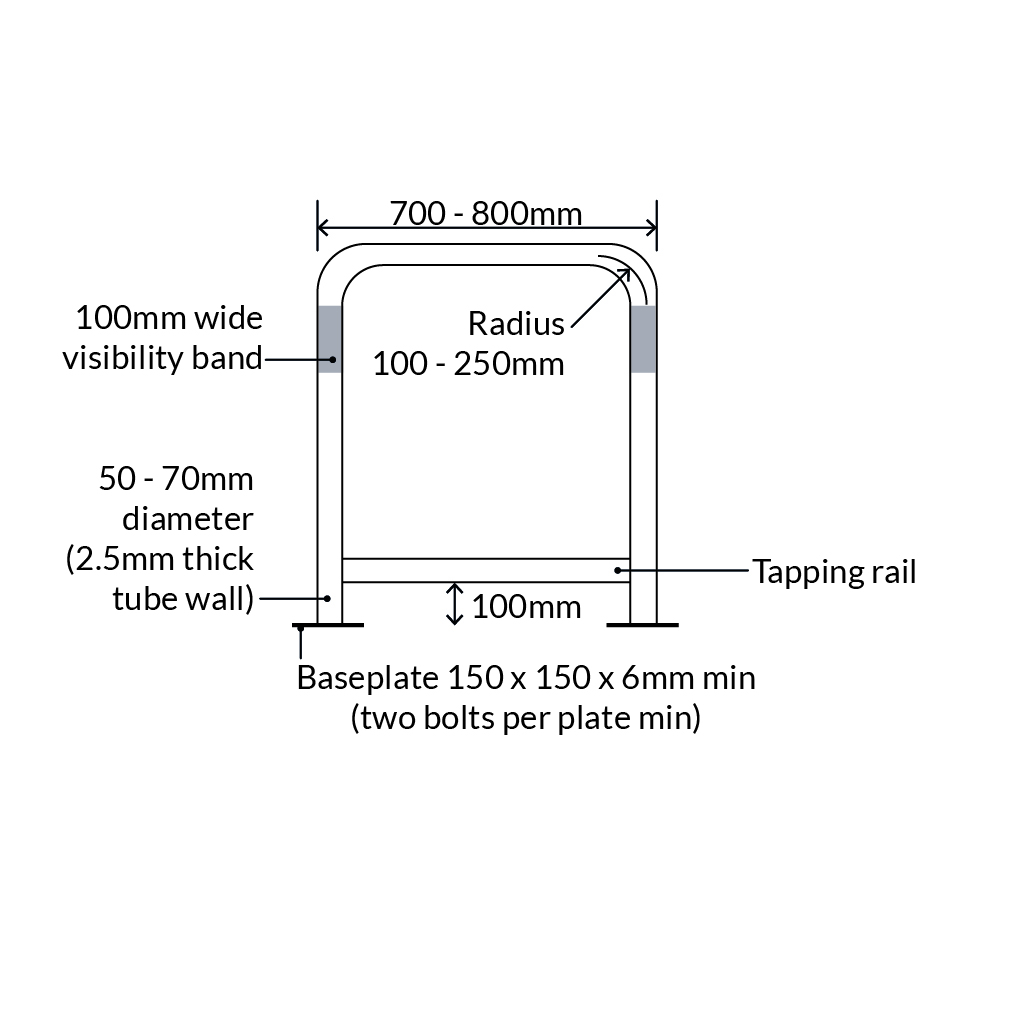
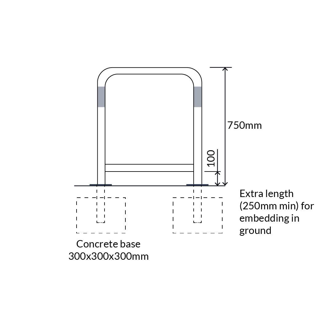
2.139 Sheffield stands are recommended due to cyclist preference and their use for two cycles on one stand, whilst also being easy to maintain and preventing damage to cycles. Fig.24 and Fig.25 illustrate the space required to accommodate this.
2.140 The stands should be embedded into a minimum of 300mm deep concrete foundations as shown in Fig.26. The addition of a tapping rail is recommended to allow children's cycles to be secured properly.
2.141 As illustrated in Fig.27, it is important that the distance between stands is measured from the centre line and at right angles to the longitudinal axis of the stand, even when stands are at an angle to a wall or a kerb line.
Figure 24
Fig.24 The overall width and length of two cycles parked on one stand
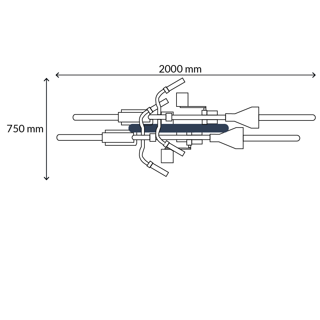
Figure 25
Fig.25 In line with LCDS Chapter 8, for Sheffield stand bays in a parallel arrangement, applicants should allow 1.2m between stands (and a minimum of 1m)
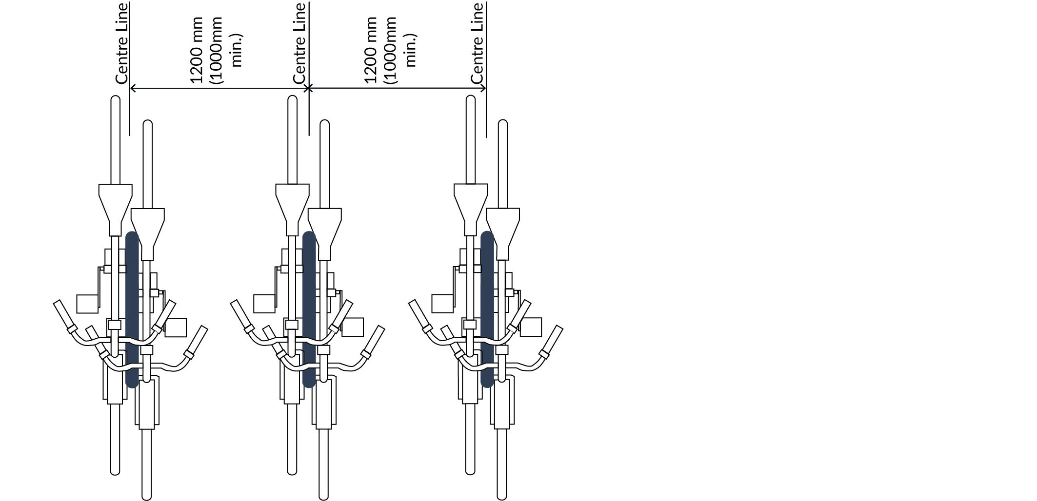
Figure 26
Fig.26 – Sheffield stand dimensions
Source: London Cycling Design Standards
Figure 27
Fig.27 Stands at 45 degrees to a wall
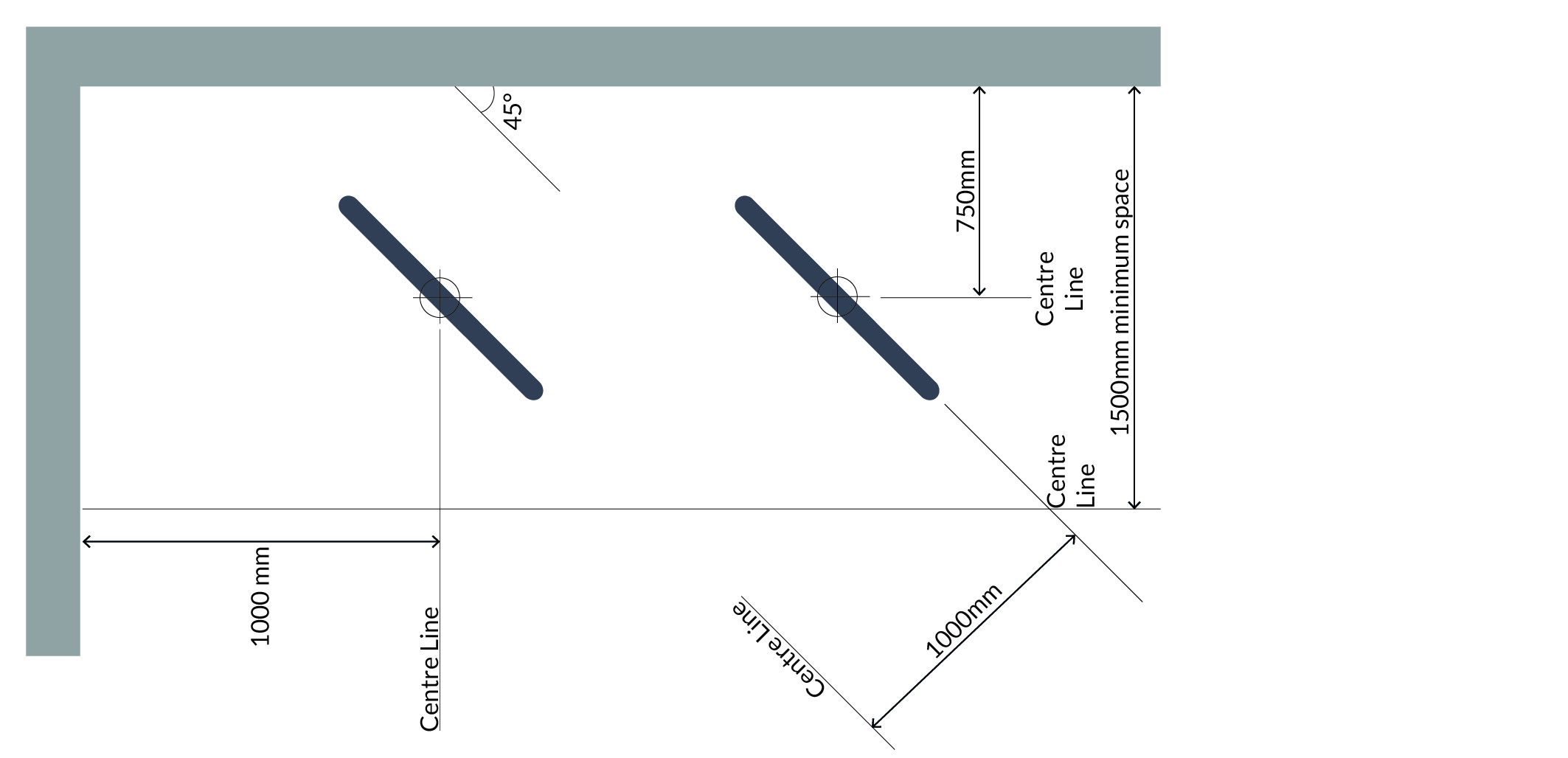
Source: Cambridge Cycle Parking Guide
Long-stay facilities
2.142 Residential and commercial cycle parking must be separated to meet distinct user needs. Fig.28 sets out design requirements for long-stay parking.
2.143 Long-stay cycle parking should be provided in close proximity to the building entrance, with direct, step-free access. If the site has vehicular access and cycles share the route with motor vehicles, the route to the cycle parking must be clearly delineated and applicants must demonstrate that parking can be accessed safely.
2.144 Access should be provided via an entrance that is overlooked, well-lit, secure and convenient to use. Direct access from the street or public realm is discouraged for residential cycle storage. Instead, access via an internal lobby is preferred to enhance safety and security.
2.145 Where internal access is unachievable, external doors fronting footways must open inward to prevent collisions with pedestrians.
2.146 For larger developments, cycle parking should be spread throughout, providing residents with options for secure storage close to their homes. A maximum number of 50 cycles is recommended within each store.
2.147 When located in an undercroft or basement car parking area, there should be separate access ramps for cyclists with a gradient less than 7%. Where ramps are shared with motor vehicles, the minimum width of the ramp should be 3.25m.
2.148 Where e-bike charging points are provided in an undercroft or basement, applicants must demonstrate compliance with Building Regulations and advice from the London Fire Brigade.
2.149 Where the provision of internal cycle storage is restricted, for example when working with an existing building with spatial limitations, or when converting terraced housing to flats, the Council will seek contributions to provide secure on-street cycle parking that is protected from the elements.
2.150 Where it has been demonstrated to the Council's satisfaction that it is not possible to provide long stay cycle parking within a small development, the Council may consider a financial contribution in lieu. This contribution will assist the Council in providing more long stay cycle parking on the public highway and will be secured via a S106 legal agreement or unilateral undertaking.
Design considerations for houses
2.151 Cycle parking should be provided within secure, covered and lockable storage preferably to the front of homes. The design should have regard for its impact on the wider street scene and materials chosen to respond to the homes.
2.152 Where required, access for cycle parking to the rear or sides of dwellings should be preferably be 1.5m, with an absolute minimum of 1.2m.
2.153 If garages are provided, these should be sized to allow cycles to be parked and easily removed without residents having to first remove their car. Refer to Fig.29 for minimum private garage dimensions.
Design considerations for mixed-use and commercial developments
2.154 Where developments consist of multiple units, each must be provided with cycle parking sized to reflect the capacity of the property.
2.155 In addition to cycle parking, amenities for cyclists should be provided at workplaces and at end of trip destinations, such as showers, changing facilities and lockers.
2.156 For new commercial developments providing food services, applicants should provide adequate waiting areas for short-term deliveries such as food delivery.
Figure 28
Fig.28 Design details for long-stay parking in residential developments
- access should not require passage through more than two doors
- external access doors should be a minimum 1.2m wide, and internal doors a minimum 1m wide
- doors should be automated, operated via push buttons or pressure pads
- the provision of storage should be a maximum of 75% two tier, 20% Sheffield and 5% adaptable stands
- within cycle stores, two-tier racks require a minimum aisle width of 2.5m beyond the upper tier frame when lowered for manoeuvrability. 3.5m is recommended for aisles with racks on both sides. The minimum height requirement is 2.6m
- Sheffield stands should be spaced 1.2m apart (1m minimum) to accommodate two bicyles per stand
Figure 29
Fig.29 Private garage with cycle parking
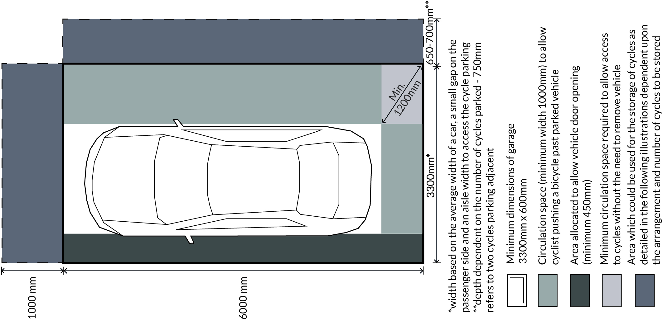
Source: Cambridge Cycle Parking Guide
Car parking
Parking layouts
2.157 The minimum dimensions for a variety of car parking bay sizes are set out in Fig.30. The minimum width for an aisleway or manoeuvring space where parking bays are perpendicular to the aisle should be 6m. The Highway Authority can provide guidance on the required dimensions for spaces and aisleways for echelon parking with one-way aisles, which will vary depending upon the angle of the parking.
2.158 Where charging for electric vehicles is proposed it should follow the guidance set out in the section on Electric Vehicle Charging Points (EVCPs) in this guidance, as well as complying with manufacturer's specifications, Building Regulations and advice from the London Fire Brigade where appropriate.
2.159 Where vehicle crossings to footways, verges or footpaths are permitted, the parking space within the site must be sufficient to accommodate the complete vehicle within the curtilage as a vehicle overhanging the highway can be a hazard for pedestrians, particularly those with impaired mobility, and this is an offence under the Highway Act 1980 and is subject to a fine.
2.160 If the Council agree to install a vehicle crossing, this does not condone this offence and the Council will take enforcement action as necessary. Where obstructions are caused, it may result in the vehicle crossing being removed and the footway, verge or footpath reinstated to its original level at the occupier's expense.
2.161 Where garages are located in blocks perpendicular to an aisleway, the minimum width of the aisle should be at least 7.5m to allow cars to enter or leave the garage in a single manoeuvre. The minimum width of the aisle may be reduced if the clear internal width of the garage and its opening can be increased.
Erith Park, Erith – Broadway Malyan
On street parking was provided adjacent to new homes on the estate, with the parking integrated into the design of the street. Soft landscaping is introduced between bays to make the route more inviting and provide greenery to the street for biodiversity benefits and improved climate resilience.
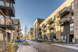

© Park East
Disabled parking provision
2.162 On-street and unallocated disabled parking bays must be designed to ensure that disabled drivers and passengers can get in and out of the car with ease.
2.163 Dropped kerbs and tactile paving should be provided adjacent to car parking and spaced to ensure wheelchair users can access footways and carriageways. It is recommended that spaces for disabled people are generally located as close as possible to building entrances.
2.164 For all developments, designated blue badge parking must be provided in line with the standards in the London Plan, including areas to transfer to wheelchairs along one side and to the rear as appropriate.
2.165 In developments where there are proportionally more older or disabled residents or visitors, then the parking and charging of mobility scooters at or near to the entrances to buildings should be considered.
Car Parking Management Plans
2.166 As active travel is encouraged and prioritised, car parking should be managed effectively and, where possible, repurposed.
2.167 Car Parking Management Plans (CPMPs) are required for the management of both new and existing parking to ensure the most efficient and sustainable land use within a site. CPMPs can take various forms depending upon the level of detail required. All Plans, irrespective of development size, should contain the information outlined in Fig.31, including details of motorcycle and cycle parking, particularly where electric charging is proposed.
2.168 These can also be in place where parking can be reduced and repurposed in the future should local transport connectivity improve, as set out in Bexley Local Plan Policy SP10 Bexley's transport network. In this case, these may also be referred to as a Car Parking Management and Reduction Plan (CPMRP).
2.169 For parking spaces to be reduced in the future, it is important that they are provided in communal areas rather than in the curtilage of an individual property. If allocated to an individual unit, this should be provided through a lease with appropriate break clauses and not freehold/permanent.
2.170 As with Travel Plans, draft CPMPs often form part of the Transport Assessment or Transport Statement. After planning permission has been granted, Final Plans will be required to manage parking and the impact of parking associated with the ongoing operation of the development.
Car clubs
2.171 The Council supports an increase in the supply of car clubs to assist residents who only need occasional use of a vehicle and can provide an alternative for a multi-car household to reduce their reliance on additional cars.
2.172 Car clubs are also a great solution where parking pressures exist and in areas where there is good public transport infrastructure and connectivity, reducing the need for residents to own a car. The environmental benefits of reduced vehicles should be reinforced by car clubs utilising vehicles using sustainable fuels wherever possible, ideally electric vehicles and either from the outset or as soon as practicable.
2.173 Developments should be designed to facilitate car clubs either when occupied or in the future and should be responsive to changes in local car driving and ownership dynamics. This includes offering the opportunity to change on-street parking spaces with ease and without detriment to the streetscape.
2.174 As an incentive to encourage reduced car ownership, developers should provide each dwelling an initial period of free membership or a specified number of hours free use, with a view to the scheme gradually becoming self-financing as membership and use increases over time.
2.175 Details of the initiatives and targets of the car club, as well as a monitoring and revision regime, should also be included in the draft and final Travel Plans and possibly also included in Car Parking Management Plans.
Car club vehicles must:
a. Be accessible and available to the wider public
b. Be operated by an accredited car club provider
c. Have dedicated and convenient parking that is identified on submitted Plans and managed according to the CPMP or CPMRP
d. Have spaces located within five minutes walk (approximately 500 metres) of the development.
Off-site parking (including permit prohibition)
2.176 There may be instances whereby a development creates parking demand that would exceed supply and the impact of the parking arising from the development would be harmful to the amenity of adjacent occupiers and operation or safety of the road network.
2.177 In such instances it may be necessary to remove parking permit eligibility through a S106 agreement or unilateral undertaking, while Traffic Management Orders (TMOs) governing existing restrictions may have to be amended, or new orders promoted.
2.178 Permit eligibility will therefore be considered for major development proposals and those in CPZs. The predicted introduction or alteration of TMOs owing to the impact of the development, including the cost of installing or amending on-street signing and lining, will be financed by a contribution from the developer.
Figure 30
Fig.30 Minimum dimensions for car parking provision
| Type of provision | Width (m) | Length (m) | Notes |
|---|---|---|---|
| Perpendicular (to the access route/street) parking spaces | 2.4 | 4.8 | |
| Perpendicular (to the access route/street) parking at end of a row | 2.7 | 4.8 | A wider space may be required to allow sufficient room for opening car doors |
| Parallel spaces at the end of a row | 2.4 | 5 | If both doors can be opened without obstruction, such as spaces along the edge of an access, the width may be reduced to 2m. |
| Parallel spaces in the middle of a row | 2.4 | 6 | If both doors can be opened without obstruction, such as spaces along the edge of an access, the width may be reduced to 2m. |
| Minimum frontage where vehicle crossings to footpaths are provided | 2.4 | 4.8 | These dimensions represent the minimum frontage that must be situated within the property to avoid any possible vehicle overhang onto public highway. |
| Minimum frontage where vehicle crossings to footpaths are provided for vehicles park parallel to the highway | 4.8 | 3 | In this case, the resident must agree to these conditions in writing before the estimate is provided and accepted by the Highway Authority. |
| Garage | 3.3 | 6 | These are the internal dimensions of the garage. If there is space in front of the garage for a car, this should be at least 5.5m deep. |
| Disabled parking bay | 2.4 | 4.8 | A 1.2m transfer clearance zone should be provided along at least one side and one end (for access to the rear of the car). |
Figure 30
Fig.31 Information to include within a Car Parking Management Plan
- design, location and layout of existing or proposed car parking
- how the site is accessed by vehicles and the interaction with vulnerable road users
- details of spaces allocated for disabled users
- details of measures to reduce car use such as Car Clubs or cargo bike parking
- details of electric vehicle charging points
- how the spaces are managed, the usage is monitored, the wrongful use of spaces is enforced, how they are allocated to individual properties and any charging mechanism
- the provision of motorbike or bicycle spaces
- a strategy to reduce the number of on-site car parking spaces in the future by repurposing the spaces for alternative use
Electric Vehicle Charging Points (EVCPs)
2.179 Developers must ensure that there is enough power and spare capacity within the electrical distribution boards in the development and submit details of the local electricity grid and confirmation that there is enough power and spare capacity at this location to support all the needs of the development, including all active and additional, anticipated demand from passive Electric Vehicle Charging Points (EVCPs) as well as any other charging facilities when the development is first occupied.
2.180 Whether within private developments or for public on-street use, all EVCPs should be installed with the latest technical requirements and to meet current standards at the time of development, as well as manufacturer's specification and advice.
2.181 Design teams should undertake detailed analysis of the specific risks to determine whether EVs can be safely located and determine what additional fire protection measures are required, such as fire suppression and adequate compartmentation. Such analysis should be undertaken by a competent, suitably qualified professional and should consider the specific nature of a potential EV fire.
2.182 Applicants must meet standards set out in all relevant London Plan policies and comply with Part S of the Building Regulations, as well as any requirements of the Council's own emerging policies. This includes locating as many EVCPs as possible in communal areas, to ensure a greater potential for future use that includes occupiers of flats and apartments as well as those with private/allocated or in-curtilage parking.
2.183 Charging facilities must be provided for disabled users and servicing vehicles where appropriate. PAS 1899 provides specifications to support the building of inclusive electric vehicle charging infrastructure.
2.184 Applicants should refer to TfL's London's 2030 Electric Vehicle Infrastructure Strategy (2021) and the 2025 updated version, Electric Vehicle Infrastructure Strategy, for information on different types of charge points, site selection, power provision and installation.
2.185 All EVCP installations should comply with the IET Standards 'Code of Practice for Electric Vehicle Charging Equipment Installation'.
2.186 There are several considerations in providing EVCPs including the location of development, purpose, vehicle type and required speed of charge.
2.187 As technology develops all parking spaces provided in developments should accommodate 'passive' charging technology, while 'active' provision must meet the minimum levels set out in the London Plan.
2.188 In Bexley, 'active' provision means that the EVCP is installed and ready to use, while 'passive' means the cabling is installed enabling the installation of electric vehicle charging infrastructure, and the future installation of the charging point.
Active provision
2.189 Active provision must be in place prior to the occupation of any part of the development unless there is a specific planning condition exempting the developer from doing so.
2.190 EVCPs should be equipped with Type 2 sockets or other sockets as required by the Council as technology evolves, and prior to granting planning permission the Council will need to agree the proposed arrangements for future maintenance as well as the proposed method of payment by users. There is a preference that shared charge points be provided with credit/debit card payment facilities in order to offer a method of ad-hoc access.
Passive provision
2.191 For passive provision - typically with residential developments - it may be necessary to ensure that the passive charge points have their own separate distribution boards.
2.192 Cabling should be provided for parking spaces that are designated for passive provision. A ground level cap should be installed at the location of each charge point to indicate the location of the cables.
2.193 Developments that have demonstrated to the Highway Authority's satisfaction that parking for essential users can be accommodated on-street will be expected to meet requirements as stated in the London Plan. On-street EVCPs may require a TMO that is subject to separate legislation and public consultation, and in such case until these procedures have been satisfactorily completed at the developer's expense the provision of the EVCP cannot be guaranteed.
2.194 In certain cases, the Council may be prepared to accept a payment in lieu to cover the cost of the TMO to convert an on-street parking bay or for a Lamp Column Charging Point within proximity to the development in the future. This must be agreed with the Highway Authority prior to any planning permission being granted.
2.195 The CPMP should set out details of how EVCPs will be managed and maintained to meet the needs of intended users. The Plan should also address how users will be charged for electricity used (if applicable); how parking spaces with EVCPs will be restricted for use by electric vehicles; when and how maintenance of the EVCP will be carried out; and what procedures will be put in place to monitor EVCP use and trigger the conversion of parking spaces from 'passive' to 'active' EVCPs.
2.196 Information regarding EV charging provision and capacity and future-proofing cabling/ducting, including opportunities for network upgrades to accommodate increased demand, should also be included in any CPMP or Travel Plans associated with the development.
Future maintenance
2.197 The layout of publicly accessible areas essential to the functioning and appearance of the development, including roads (adopted or unadopted highways), footways, footpaths and landscaping, will be considered during determination of a planning application. This information, and details of the long-term maintenance strategy should, therefore, be presented during the pre-application process and included within the subsequent planning application.
2.198 The private maintenance of publicly available areas that will not be adopted by the Council will be controlled through a suitable legal agreement, under S106 of the Town & Country Planning Act 1990 and/or S101 of the Local Government Act 1974, which will include the identification of the formal 'Street Manager'.
2.199 Where new roads have significant public benefit, or where they might benefit the wider highway network, the roads may be adopted using an agreement between the developer and the Council under S38 of the Highways Act.
2.200 This will be at the Council's discretion, and even where some infrastructure is to be adopted by the Council, ancillary areas such as verges, sight-lines and sustainable urban drainage systems (SuDS) may have maintenance liability transferred to third parties. In this instance, the Council will need to retain sufficient rights to ensure that the use of these areas does not prejudice highway functions.
2.201 Alterations to the publicly maintained highway by the developer will be subject to an agreement with the Council under S278 of the Highways Act 1980, while minor alterations to the footway such as a vehicle crossing will be carried out by the Council at the applicant's expense under S184 of the Act.
Private maintenance agreements
2.202 Where publicly-accessible areas will not be adopted by the Council, and prior to the first occupation of the new development, a Street Management Plan (SMP) should be submitted to, and approved in writing by, the Local Planning Authority to cover all the streets and ancillary areas and the public realm. The approved Plan should be implemented upon first occupation of any new building and remain in place for the lifespan of the development.
2.203 The SMP should include the information set out in Fig.32, particularly the procedure and funding of cyclic and other maintenance inspections and works, and clearly identifying the public areas being maintained privately.
2.204 Suitable signage, confirming the private maintenance status, and that there is not intention to request adoption by the Council in the future, should be installed on site within these areas as required by the Council.
2.205 To ensure the ongoing maintenance and management of streets and ancillary areas within the public domain preserve the quality of development required by the Bexley Local Plan, any repair works undertaken on the highway should submit a notification to the Street Works Manager as dictated by the Traffic Management Act 2004.
Adoption by the Council
2.206 Where the Highway Authority considers there is sufficient public benefit for the streets to be adopted by the Council under a S38 agreement, or the existing highway is altered using S278, the developer will remain responsible for maintenance of the works until the Final Completion Certificate is issued by the Highway Authority after the satisfactory completion of the maintenance period.
2.207 Signatories to a S38/S278 agreement normally include the Council, the developer and any surety provider. Detailed agreement guidance is available from transportanddevelopment@bexley.gov.uk or highwayagreement@bexley.gov.uk.
2.208 The clauses of the agreement outline the standards the Council requires new areas to be built to, and which the developer will need to uphold satisfactorily for a maintenance period, which is typically a year after Practical Completion. Other clauses in the agreement often include:
- responsibility for the maintenance of the road prior to adoption
- payment of fees by the developer to the Council for technical approval and inspection of the works during construction
- any land transfer or wayleave agreements
- what happens if things do not go as planned
2.209 The technical approval and inspection process will require the submission of specifications and drawings for approval as required by the Highway Authority as well as before any work can commence on site.
2.210 The permit application will also need full traffic management proposals, while the technical submission in connection with the legal agreement will also include final as-built drawings, asset register details and the Health & Safety file at the completion of the works prior to formal adoption.
2.211 The Council's costs for the agreement process is based on a sliding scale related to the estimated value and complexity of the works and needs to be paid when the agreement is signed. An initial non-returnable fee that will form part of the final total fee will need to be paid to cover the Council's preliminary costs before the technical audit process commences, as the total fee cannot be finalised until the audit is complete.
2.212 Should the Council require specialist advice for the technical approval, then the costs of the initial non-returnable fee and total fee may need to be increased.
2.213 A bond of surety for the full estimated value of the work will need to be secured in case the Council has to intervene and complete the scheme for any reason. The Council may be prepared to accept a returnable deposit for the full value of the works in exceptional circumstances but this approach is not encouraged.
2.214 Developers will also be responsible for commuted sums for any adoptable infrastructure works that will involve the Council in extra, special or expensive maintenance in the future. Commuted sums may be required for infrastructure in the public realm not directly related to streets and travel (such as lighting, cleansing infrastructure, playground equipment and sports facilities), while in connection with highways and streets commuted sums will normally, but not exclusively, be required for:
- retaining walls and other structures
- specialised new street furniture
- soakaway and sustainable drainage systems (including rain gardens)
- trees and soft landscaping
- innovative construction materials (including blockwork and granite surfaces)
- any additions or alterations to the Council's (digital) infrastructure
2.215 Commuted sums will also be required by Transport for London in connection with any traffic signal works or alterations to their bus facilities including digital infrastructure.
2.216 The payment of the fees relating to technical audit and inspection, or commuted sums for future maintenance, does not relieve the developer of their responsibility to apply, pay for, and obtain the necessary licence required before they can start work in the highway. This should be sought from the Council's Street Manager reachable at swpermits@bexley.gov.uk or Section50Licences@bexley.gov.uk.
Easements over private land
2.217 In some cases, it may be necessary for an easement to be granted over private land to enable the Council to gain access to infrastructure they are responsible for, such as retaining walls or drainage apparatus. This ensures that this infrastructure can be inspected and maintained by the Council in the future where access is not available from the highway.
Figure 32
Fig.32 Information to be included in a Street Management Plan
- details of the Street Manager/operator of the SMP, and relationship with future occupiers;
- phasing of delivery of SMP;
- a maintenance regime for all areas accessible to the public including time periods for any necessary works or cyclic maintenance;
- means of preventing vehicles using areas of land to be used for amenity purposes or by public on foot;
- maintenance regime for all road marking and traffic signs;
- payment for energy costs of any street lighting or illuminated signs;
- a mechanism to ensure that cyclic inspections and maintenance works, as well as any emergency or unplanned incidents, are carried out when required; and
- confirmation of procedure for emergency repairs, and timescales if not completed that would trigger action by the Council and how any consequent recharge of the costs incurred will be met
Other consents and agreements
2.218 The granting of planning permission (and building regulations approval) may not be the only consent required to carry out a development, and many of the others relate to highway and transport matters.
2.219 The application for and granting of such licenses and consents may take several weeks, and where the activity needs to be coordinated with other planned or emergency highway works this can lead to delays before works or utility connections can be carried out. Developers should allow for potential delays when programming works.
2.220 There are several service areas within the Council that carry out 'highway' functions, however the principal contact for development-related works is the Transport & Development (T&D) team.
2.221 The T&D team are responsible for setting the Council's policies and acting on behalf of the Highway Authority in many respects including planning applications, monitoring Travel Plans and highway-related planning obligations, the technical audit and inspection of highway works and maintaining the Council's highway records. The usual continuum for developer-related works is shown in Fig.33.
2.222 The T&D team will liaise, and ensure effective engagement, with the other Council 'highway' teams.
2.223 A summary of contact details for all highways services teams are listed in Fig.34. When contacting these teams, the T&D team should be copied into emails to assist with their coordination role and avoid unnecessary delays.
2.224 A general indication of the different consents that may be required in connection with the approval, construction, and ongoing operation of the development, and the 'highway' team that would process the application is provided in Fig.35.
Figure 33
Fig.33 Council teams for applicants to engage with over the course of implementing a development project
| Stage |
|---|
| Pre-application discussions T&D |
| Planning process T&D |
| Technical approval of highway works T&D |
| Works on site T&D / AT |
| Adoption and update of highway and land search records T&D |
Figure 34
Fig.34 Contact details for highways service areas
| Team | |
|---|---|
| Transport and Development (T&D) | transportanddevelopment@bexley.gov.uk or highwayagreements@bexley.gov.uk |
| Street Works Team (SWT) | section50licences@bexley.gov.uk or swpermits@bexley.gov.uk |
| Traffic | traffic@bexley.gov.uk |
| Area Teams (AT) | areateamsupport@bexley.gov.uk |
| Environmental Services (ES) | highway.enforcement@bexley.gov.uk |
| Grounds Maintenance (GM) | groundsmaintenance@bexley.gov.uk |
Figure 35
Fig.35 Consents required for a development project and relevant Council team to consult
Key: T&D - Transport & Development; SWT - Street Works Team; T - Traffic; AT - Area Teams; GM - Ground Maintenance
| Development stage | Consent or licence | 'Highway' Team |
|---|---|---|
| Prior to full scheme approval | Highway Stopping Up Orders and Dedication | T&D |
| Prior to full scheme approval | Rights of Way Extinguishment and Diversion | T&D |
| Prior to full scheme approval | Traffic Management Orders | T&D, T |
| Prior to commencing works | Highway Condition Surveys | T&D, AT |
| Prior to commencing works | Demolition & Construction Traffic | T&D |
| Prior to commencing works | Temporary Direction Signs | T |
| Prior to commencing works | Hoarding, Scaffolding and Skip Licences | AT |
| Prior to commencing works | Crane or Mobile Elevated Work Platform for Construction | SWT |
| Prior to commencing works | Storing Materials on the Highway | AT |
| Prior to commencing works | Temporary Traffic Orders or Closures for Works | SWT |
| Prior to commencing works | Rights of Way Temporary Closure or Diversion | SWT |
| Prior to commencing works | Street Works Licences and Permits | SWT, AT |
| Prior to commencing works | Approval of Temporary Access | T&D, AT |
| Prior to commencing works | Approval of Permanent Highway Works | T&D |
| Prior to commencing works | Removal / relocation of Street Trees | T&D, AT, GM |
| Prior to commencing works | Future Maintenance of Public Areas & Infrastructure | T&D, AT, GM |
| Prior to commencing works | Traffic management plans for temporary arrangements during works | SWT, AT |
| Prior to commencing works (cont.) | S58 protection application for highways improvements | SWT, AT |
| Prior to commencing works (cont.) | Disconnection of utility services | SWT, AT |
| During demolition and construction | Highway Cleansing | AT |
| During demolition and construction | Construction of Temporary & Permanent Accesses | T&D, AT |
| During demolition and construction | Construction of Off-Site Highway Works | T&D |
| During demolition and construction | Construction of Future Public Areas | T&D, AT, GM |
| During demolition and construction | Crane Licences | SWT |
| During demolition and construction | Street Works Notices for off-site highways works | T&D, SWT |
| Prior to occupation or operation | Approval of Highway Works (inc Privately Maintained) | T&D, AT, GM |
| Prior to occupation or operation | Crane or Mobile Elevated Work Platform (MEWP) | T&D, SWT |
| Prior to occupation or operation | Approval of Retaining Walls & Projecting Structures | T&D |
| Prior to occupation or operation | Approval of Highway Landscaping | T&D, GM |
| Prior to occupation or operation | Utility service connections | SWT |
| Prior to occupation or operation | Street Works Notices for service connections | SWT |
| Prior to occupation or operation | Temporary traffic management for utility connections | SWT |
| Ongoing operation | Advertising or A-Boards on the Highway | AT |
| Ongoing operation | Monitoring, Reviewing and Updating Travel Plans | T&D |
| Ongoing operation | Crane licences for building maintenance | SWT |
| Ongoing operation | Street Works licences for snagging | SWT |
| Ongoing operation | Street Works Notices for ongoing maintenance requiring excavation or opening of the highway (visual inspection) | SWT |
Prior to commencing works
Pre-construction surveys
2.225 Where the Highway Authority considers that demolition or construction works may result in larger or heavier vehicles using roads that may be inadequate, in terms of width, alignment or construction, the developer will be expected to carry out a full pavement condition survey before any work commences on the site. Any part of the road, footway or verge that is not in the same condition after all works have been completed will need to be returned to the previous condition at the applicant's expense.
2.226 Fig.36 sets out information to be included in a highway condition survey, to identify the existing state of the highway in the vicinity of the site.
2.227 This may form part of a Construction Management Plan or Construction Logistics Plan, or as an agreement under S59 of the Highways Act 1980.
2.228 The Area Team responsible for maintenance will carry out joint visual inspection once the information set out in Fig.36 has been submitted by the developer and before and after the development has been carried out to ensure that any remedial work for possible damage to highway, including temporary access(es) at the development's location are agreed. As part of the pre-commencement inspection that applicant must ensure that any temporary excavation licences are applied, paid for and are confirmed by the Council.
Figure 36
Fig.36 Information to be included in a highway condition survey
- a plan which identifies the area covered by the survey
- a written report detailing the current condition of the roads and footways, footpaths, verges and any highway structures or boundary enclosures in the vicinity of the site (the Council has the ability to carry out a video survey, which may be available to the developer for a fee)
- a list of highway defects prior to the commencement of works, including specific photographs identifying the individual defects
- a photographic overview of the roads and footpaths in the vicinity of the site
- an estimate of the size, types and level of construction traffic expected to service the site, during the development period (including demolition, construction, and any maintenance/warranty periods for the buildings and/or structures involved)
Demolition and construction traffic
2.229 Management of traffic involved in demolition and construction works, including the size, frequency and routeing of vehicles, will normally be dealt with through a Construction Management Plan or Construction Logistics Plan, or as mentioned in Travel Plans outlined earlier in this chapter.
Temporary signage
2.230 Permission for temporary direction signs leading to the development should be obtained from the Council in advance. If temporary signs are erected without permission, these may be removed by the Highway Authority who will seek reimbursement from the developer for their associated costs. Further details on temporary signage can be obtained from the Traffic team.
2.231 Unauthorised signs will be classed as fly posters and will be removed. Environmental Services, contactable by the email noted in Fig.34, will issue Fixed Penalty Notices.
Licenses for hoardings, scaffolding, skips & the deposit of materials
2.232 Licences under the Highways Act 1980 for hoardings (S172 & S173), scaffolding (S169), skips (S139) and the deposit of materials (S171) are dealt with by the Environmental Services team.
2.233 The conditions for issuing these as well as application forms and information on applicant's responsibilities can be downloaded from the Council's website.
2.234 Whilst these tend to be related to the on-site construction works rather than transport issues, their siting and maintenance can affect the safe use of the adjoining highway, especially if they are positioned at or near the site's boundary.
2.235 The use of 'green hoardings' will be considered where appropriate. These should incorporate climbing plants or grass/wildflower mats that can assist with dust suppression and deter graffiti/fly posting, so may be acceptable provided that they are properly managed and do not result in an adverse impact on lighting or public safety.
2.236 At the time of submitting the application and throughout the period of works, it should be ensured that these items are not positioned within sight lines or across sections of footway, verge or footpath, or so close to street furniture, such as lamp columns, that they preclude access for maintenance.
Cranes and mobile platforms
2.237 Permission is required to use the highway for cranes, temporary crane over-sail licences and Mobile Elevated Work Platforms (MEWPs) by the issue of licences/permits under S171 and 177 of the Highways Act 1980.
2.238 Items placed on the highway without a valid permit are an illegal obstruction and the Council can take enforcement action, and may seek the reimbursement of costs of removal, storage or disposal from the developer.
2.239 Crane applications should be made through the Council's website under Street Works Licences. Additional information can be obtained from the Street Works Team.
2.240 Crane licences must be notified to the Street Works Register, coordinated with planned activity in the highway, and may require temporary traffic management. In such cases, temporary traffic management plans should be produced and submitted for approval prior to works starting.
2.241 Applications for permanent over-sail licences for building projects or bridges above the highway, if not identified as part of the planning application, should still be raised with the T&D team.
Temporary closures
2.242 Demolition and construction works sometimes require a temporary road closure or parking bay suspension, particularly where heavy plant and machinery is in use, or excavation of the highway is required. Such closures will require the preparation and granting of an Order(s) under S14 of the Road Traffic Regulation Act 1984 to temporarily prohibit vehicular traffic. Further details should be obtained from the Street Works Team.
2.243 If an objection is raised and upheld, then the Order will not be made, and the road cannot be closed.
2.244 Temporary closures must be notified on the Street Works Register and have to be coordinated with planned activity in the highway, with appropriate traffic management plans submitted and agreed by the Council prior to the making of an Order.
2.245 The advance notification period for this can vary depending on the extent of the works but can be more than three calendar months. Developers should allow for such delays when preparing their project programmes.
Temporary access
2.246 Under the Highways Act 1980, approval must be given for access to the site for demolition and/or construction whether via a temporary access or part of permanent works.
2.247 A temporary access may require planning permission, as the legislation does not differentiate between temporary or permanent works. Where permanent access requires planning permission, approval for a temporary access as a part of the permanent works should be sought from the T&D team.
2.248 If access is provided by a vehicle crossing over the footway, verge or footpath, under S184 of the Act, details should be agreed in discussions with Area Teams, who will carry out the agreed work at the applicants expense.
2.249 Temporary excavation licences must be applied and paid for prior to works commencing.
Street works permits
2.250 Under the Traffic Management Act 2004, the Council has a responsibility to coordinate and monitor works undertaken on the highway. This includes temporary excavation licences for trial holes or proposed alterations to the street under S171 of the Highways Act 1980, or a licence to install apparatus such as drainage or utility services under S50 of the New Roads & Street Works Act 1991 (NRSWA).
2.251 Notices relating to the future commencement of work on site under S171 of the Highways Act 1980 or S50 of the NRSWA, including approval of traffic management, are dealt with by Street Works Team. Applicants are encouraged to make early contact with the team.
2.252 Site safety remains the responsibility of the developer. All sites should clearly display details of who is carrying out the works and contact details in case of an emergency.
Permanent access & off-site highways works
2.253 Approval of the details of the permanent access and off-site works is dealt with by the T&D team, who also approve and inspect the construction of highway works under S38 and S278 of the Highways Act 1980. The approval of the details of any permanent closure of an existing access (S124 of the Act) will also be considered.
2.254 Advance notification periods are specified within the Traffic Management Act. As the licence holder will not have access to an EToN system, these manual applications will be entered on the Street Work Register by the Street Works Team as part of the permit/licence approval process.
2.255 Safety remains the responsibility of the licence holder and their contractor. All works must comply with the latest safety codes of practice, including Chapter 8 of the Traffic Signs Manual and TfL Temporary Traffic Management Guidance, and any works in contravention of such will be subject to enforcement.
2.256 All sites must clearly display information boards which include the name of the company carrying out the works, and a 24-hour contact number for queries and emergencies.
2.257 If further works are required for snagging, or multiple phases of works planned, these must be notified separately. A licence is valid for one year from the date of issue and can be renewed if remedial works are required following expiry.
Section 58 - protection of the highway
2.258 A S58 Notice under the NRSWA may be put in place to ensure the integrity of the highway after substantial works, resurfacing or reconstruction of at least 30m continuous length in either the footway, verge, footpath or the carriageway.
2.259 This must be submitted at least three months before the works commence and can be arranged through the Street Works Team as part of the S50 licence process.
Utility service connections
2.260 It is the responsibility of the developer to ensure that utility service disconnections and reconnections under a S50 licence are applied for in good time.
2.261 Standard notification periods are applied in accordance with the Traffic Management Act 2004, which can be as much as three months dependant on the type of works required.
Temporary traffic management plans
2.262 Temporary traffic management plans must be provided for each phase of highways works and may incur a cost. Plans should be to scale and be prepared in accordance with Chapter 8 of the Traffic Signs Manual and the Safety at Street Works and Road Works: Code of Practice.
2.263 These must be submitted to the Street Works Team for assessment using the email address(es) in Fig.34
During demolition and construction
Protection of existing highway
2.264 Applicants are required to comply with the following legislation to ensure the maintenance and protection of existing highway during demolition and/or construction:
- S6 London Local Authorities and Transport for London Act 2013 with regards to damage to the highway caused by the developer.
- The Act states that if a highway is damaged by, or as a result of, works on land adjacent to the highway, the Highway Authority can remedy the damage and seek reimbursement from the landowner, the person carrying out the works, or the person on whose behalf the works are being carried out.
- S149 of the Highways Act 1980 addresses the removal of anything deposited on the highway which causes a nuisance or obstruction, for example mud left on the highway as a result of works.
- S151 & S163 of the Act 1980 relates to soil washing and water flowing onto and off the highway.
- In this instance, the Highway Authority may notify a landowner to their requirement to undertake works to prevent soil and refuse from their land falling, or being washed or carried, onto the highway (or sewer or gully) that should cause obstruction to this infrastructure. Following notice being served, the landowner has 28 days to undertake these preventative works.
Prior to occupation or operation
Future maintenance
2.265 With regards to new roads, agreement on their maintenance must be reached with the Highway Authority (T&D).
2.266 S38 of the Highways Act 1980 provides a mechanism for the public maintenance/adoption of a new highway by the Council.
2.267 This section of the Act can be used when a developer proposes the construction of a new estate road for residential, industrial or general-purpose traffic that may be offered to the Highway Authority for adoption as highway.
2.268 S37 & S228 of the Highways Act 1980 relates to the adoption of existing unadopted highway ('private street') by the Council.
2.269 Where an area of highway is to remain privately maintained this can be controlled through a S106 planning agreement or planning condition, or an agreement under S101 of the Local Government Act 1972.
Ancillary items
2.270 When proposing new features along highways, applicants must comply with the following legislation:
- S142 of the Highways Act 1980 relates to the licence that may be granted by the Highway Authority to allow the frontager permission to plant, or retain, and maintain soft landscaping such as trees, shrubs, plants and grass on a publicly maintained highway.
- S167 of the Highways Act 1980 applies to retaining walls near streets. Plan and section drawings should be provided to the Council for approval alongside relevant specification information.
2.271 Non-compliance with this legislation will result in the applicant paying a fine for contravening the legislation set out in the Act:
- S16 of the London Local Authorities and Transport Act 2013 provides legislation on the installation of Electric Vehicle Charging Points within the highway and public off-street car parks.
- Part IV of the Road Traffic Regulation Act 1984 relates to all aspects of parking places, such as the power of local authorities to provide parking places, off-street parking places and the display of information.
- S177 & S178 of the Highways Act 1980 outlines restrictions in place on the construction of buildings and apparatus over highways.
2.272 This states that applicants will typically not be permitted to construct a building over any part of a highway without a licence granted under this section of the Act by the Highway Authority.
2.273 Any licence granted may include terms and conditions with respect to the construction, maintenance, lighting and use of the building as deemed appropriate by the Highway Authority.