Our Highway Network
The London Borough of Bexley is responsible for maintaining a public highway network that includes over 570 kilometres (354 miles) of roads. The majority of these are urban, residential streets (‘U’ class roads), typically with footways on both sides. As a result, the total length of footways maintained is 767 kilometres (476 miles).
Bexley does not maintain any trunk roads or motorways. The major roads of the A2 and A20 fall under the responsibility of Transport for London (TfL), as part of their strategic road network.
The table below provides a breakdown of Bexley’s highway network by road classification and/or category:
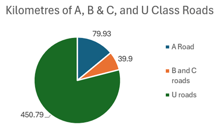
| A Road (Main Roads) | B and C roads (Key Roads) | U roads (Residential Roads) | Total Roads | Footways | Other Public rights of way | Cycleways (National cycle routes) |
|---|---|---|---|---|---|---|
| 79.93km | 39.90km | 450.79km | 570.62km | 767.74km | 59.61km | 6.22km |
| 49.67miles | 24.79miles | 280.11miles | 354.57miles | 477.05miles | 37.04miles | 3.86miles |
In addition, the Council is responsible for maintaining:
- Over 23,000 road gullies, which collect rainwater from the highway surface and discharge it into Thames Water sewers, local watercourses, soakaways, or underground storage systems.
- More than 19,500 street lights, all equipped with energy-efficient LED units, designed to provide appropriate lighting levels based on the classification of the road or footpath.
- A total of 174 highway structures, including 55 bridges, 16 subways, 35 footbridges, 10 culverts, and 58 retaining walls. These structures support the safe movement of vehicles and pedestrians over or under roads, railways, and rivers.
Note: Traffic signals, safety/speed cameras, or ULEZ (Ultra Low Emission Zone) cameras are the responsibility of Transport for London (TfL).