Contents
- Executive summary for the Pharmaceutical Needs Assessment (PNA) 2025
- Section 1: Introduction
- Section 2: Context for the PNA
- Section 3: NHS pharmaceutical services provision, currently commissioned
- Section 4: Other services that may impact on pharmaceutical services provision
- Section 5: Findings from the public questionnaire
- Section 6: Analysis of health needs and pharmaceutical service provision
- Section 7: Conclusions
- Appendix A: List of pharmaceutical service providers in Bexley by locality
- Appendix B: PNA project plan
- Appendix C: PNA Steering Group terms of reference
- Appendix D: Public questionnaire
- Appendix E: Consultation stakeholders
- Appendix F: Summary of consultation responses
- Appendix G: Consultation comments
- Appendix H: List of Abbreviations
- Supplementary Statements and map updates
4. Section 3: NHS pharmaceutical services provision, currently commissioned
3.1 Overview
There is a total of 45 contractors in Bexley.
| Type of contractor | Number |
|---|---|
| 40-hour community pharmacies (including one PhAS provider) | 42 |
| 72-hour community pharmacies | 1 |
| Distance Selling Pharmacy | 2 |
| Local Pharmaceutical Service providers | 0 |
| Dispensing Appliance Contractors | 0 |
| GP dispensing practice | 0 |
| Total | 45 |
A list of all contractors in Bexley and their opening hours can be found in Appendix A. The figure below shows all contractor locations across all three localities in Bexley and the border.
Figure 11: Map to show all pharmacy contractors in Bexley
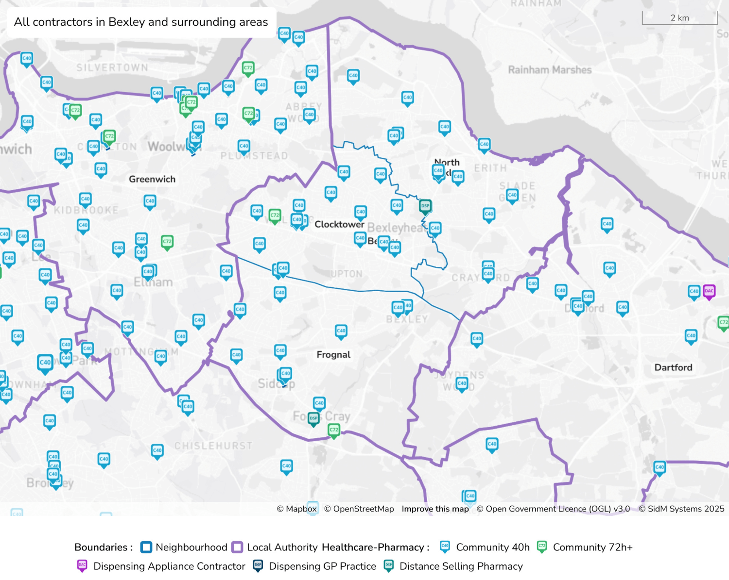
Figure 11 - text description
- This map displays the locations of all pharmacy service contractors in the London Borough of Bexley and surrounding areas, including parts of Greenwich, Dartford, and Bromley. It shows a detailed distribution of pharmacy service points using distinct icons to represent different types of contractors. Light blue icons labeled "C40" denote community pharmacies open for 40 or more hours per week and are the most numerous and widely spread across the region, found mostly dispersed in Greenwich, Clocktower and North Bexley. Green "C72" icons represent community pharmacies operating for 72 or more hours per week, which appear less frequently, mostly found in the upper regions of Greenwich. Teal icons identify distance selling pharmacies and purple icons represent dispensing appliance contractors, where just one appears in Dartford. The boundaries of Bexley as a local authority are marked with thick purple lines, while locality boundaries are outlined in blue. Overall, the map highlights a strong presence of community pharmacies, ensuring wide accessibility to core pharmaceutical services, while also noting that more specialised services, such as appliance contractors and distance-selling pharmacies, are relatively limited in number and coverage.
3.2 Community pharmacies
3.2 Community pharmacies
Number of community pharmacies | Population of Bexley | Ratio of pharmacies per 100,000 population* |
| 45 (includes 2 DSPs) | 246,466 | 18.3 |
*Correct as of June 2025
There are 45 community pharmacies in Bexley, which has decreased from 46 in the last PNA. The England average is 18.1 community pharmacies per 100,000 population, which has decreased from 2021, when the average number was 20.6. The Bexley average of 18.3 pharmacies per 100,000 is slightly higher than the national average. Section 1.2 noted the level of national community pharmacy closures due to funding challenges and workforce pressures. Table 38 shows the change in the numbers of pharmacies over recent years compared with regional and national averages.
| Year | Bexley | England |
|---|---|---|
| 2023 to 2024 | 18.3 | 18.1 |
| 2020 to 2021 | 18.5 | 20.6 |
| 2019 to 2020 | 18.5 | 21.0 |
| 2018 to 2019 | 18.8 | 21.2 |
Source: ONS 2020 and 2023 mid-year population estimates and NHS BSA for England for number of pharmacies.
Section 1.5.1.4.1 lists the Essential Services of the pharmacy contract. It is assumed that provision of all these services is available from all contractors. Further analysis of the pharmaceutical service provision and health needs for each locality is explored in Section 6.2.
Table 39 provides a breakdown, by locality, of the number of community pharmacies per 100,000 population. The number and rate of community pharmacies vary widely by locality.
| Locality | Number of community pharmacies | Total population (ONS mid-2023 population) | Average no. of community pharmacies per 100,000 population (Oct 2024) |
|---|---|---|---|
| North Bexley | 16 | 98,452 | 16.3 |
| Clocktower | 15 | 79,769 | 18.8 |
| Frognal | 14 | 68,245 | 20.5 |
| Bexley | 45 | 246,466 | 18.3 |
| England (2023)1 | 10,454 | 57,690,323 | 18.1 |
3.2.1 Distance-Selling Pharmacies (DSPs)
Distance-Selling Pharmacies are described in Section 1.5.1.2. There are two DSPs in Bexley, one more than the previous PNA. Details can be found in Appendix A.
3.2.2 Weekend and evening provision
In May 2023 the Pharmaceutical Regulations 2013 were updated to allow 100-hour pharmacies to reduce their total weekly core opening hours to no less than 72 hours, subject to various requirements.
In the 2022 PNA, Bexley had one 100-hour pharmacy (2%), and now has the one 72-hour pharmacy in 2024. Nationally there has been a decline with the number of 100-hour community pharmacies in England open in 2022 being 9.4% and now for 72 hours or more per week being 7.7%.
The 72-hour pharmacy in Bexley is in Clocktower locality.
| Area | Number (%) of 72-hour pharmacies |
|---|---|
| North Bexley | 0 |
| Clocktower | 1 |
| Frognal | 0 |
| Bexley | 1 (2%) |
| England | 806 (7.7%) |
3.2.3 Access to community pharmacies
Community pharmacies in Bexley are particularly located around areas with a higher density of population, as seen in the map below.
Figure 12: Map to show population density across Bexley with pharmacies overlayed
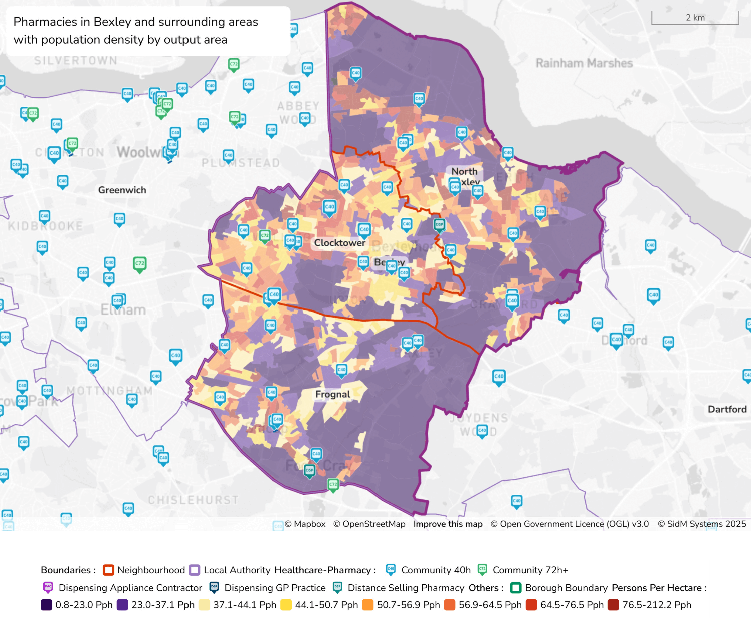
Figure 12 - text description
- The map shows the locations of pharmacies in Bexley and surrounding areas, overlaid with population density by output area. Pharmacy types include healthcare pharmacies, community pharmacies (40 or 72+ hours) and distance selling pharmacies. The background shading indicates population density, with darker purple representing lower density (0.8–23.0 persons per hectare) and progressing through lighter colours—yellow, orange, and red—to indicate increasingly high-density areas (up to 212.2 persons per hectare). Notably, Clocktower and parts of North Bexley display higher population density areas (yellow to red shades), accompanied by numerous pharmacies. Frognal generally has lower to medium population densities with pharmacies reasonably distributed across the locality. Locality boundaries (orange) and the local authority boundary (purple) clearly demarcate the geographical areas for ease of interpretation.
A previously published article3 suggests:
- 89% of the population in England has access to a community pharmacy within a 20-minute walk
- this falls to 14% in rural areas
- over 99% of those in areas of highest deprivation are within a 20-minute walk of a community pharmacy
The same study found that access is greater in areas of high deprivation. Higher levels of deprivation are linked with increased premature mortality rates and therefore greater health needs.
3.2.3.1 Routine daytime access to community pharmacies
The following maps and table below show travel times to community pharmacies using a variety of options. A breakdown of travel within each locality is shown within Section 6.2.
| Method and time band | Population within travel time band |
| Walking 0-10min | 60% |
| Walking 0-20min | 98% |
| Walking 0-30min | 100% |
| Driving peak 0-10min | 100% |
| Driving peak 0-20min | 100% |
| Driving peak 0-30 min | 100% |
| Driving off-peak 0-10min | 100% |
| Driving off-peak 0-20min | 100% |
| Driving off-peak 0-30 min | 100% |
| Public transport 0-15min | 93% |
| Public transport 0-30min | 99% |
Summary:
- 98% of the population are able to walk to a pharmacy within 20 minutes
- 100% of the population in Bexley can get to a pharmacy within 20 minutes when choosing to drive, whether this is off peak or at peak times
- 97% are able to travel via public transport to a pharmacy within 20 minutes
Figure 13: Map to show average walk times to community pharmacies in Bexley
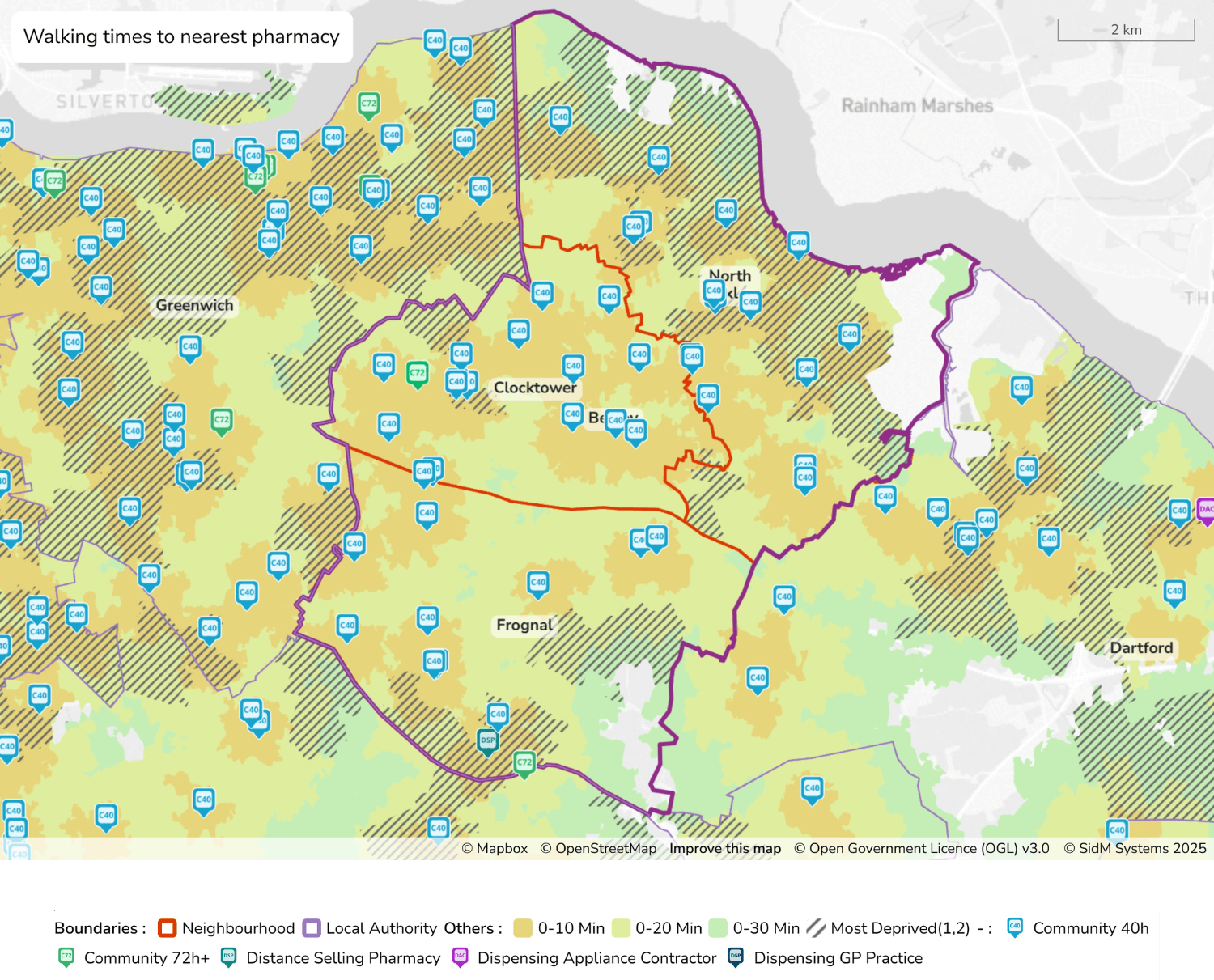
Figure 13 - text description
- This map shows estimated walking times to the nearest pharmacy across the London Borough of Bexley and nearby areas, including parts of Greenwich and Dartford. The walking times are colour-coded: Orange areas represent locations within a 0–10 minute walk to the nearest pharmacy and are found mostly in Clocktower. Light yellow areas indicate 0–20 minutes and make up the majority of Frognal. Green areas reflect walking times of 0–30 minutes, which are a lot rarer but can be found in Northern North Bexley and Dartford. Areas with diagonal black hatching mark localities identified as being in the most deprived deciles (1 or 2) according to national deprivation rankings. These areas are predominantly found in North Bexley and Greenwich. Pharmacy locations are shown using various icons: light blue "C40" icons denote community pharmacies open for 40 or more hours per week, and are the most common; green "C72" icons represent those open for 72 or more hours; teal icons indicate distance selling pharmacies. Locality boundaries are outlined in orange, while the Bexley local authority boundary is marked with a thick purple line. The majority of Bexley is within a 0–10 minute walking distance to a pharmacy. However, some small peripheral areas on the eastern and southern edges of the borough fall into the 20–30 minute walking range. Several of the most deprived areas overlap with zones that fall outside the 10-minute walking time, in particular the Northen region of North Bexley.
Figure 14: Map to show drive times by car to the nearest pharmacy in Bexley (off peak)
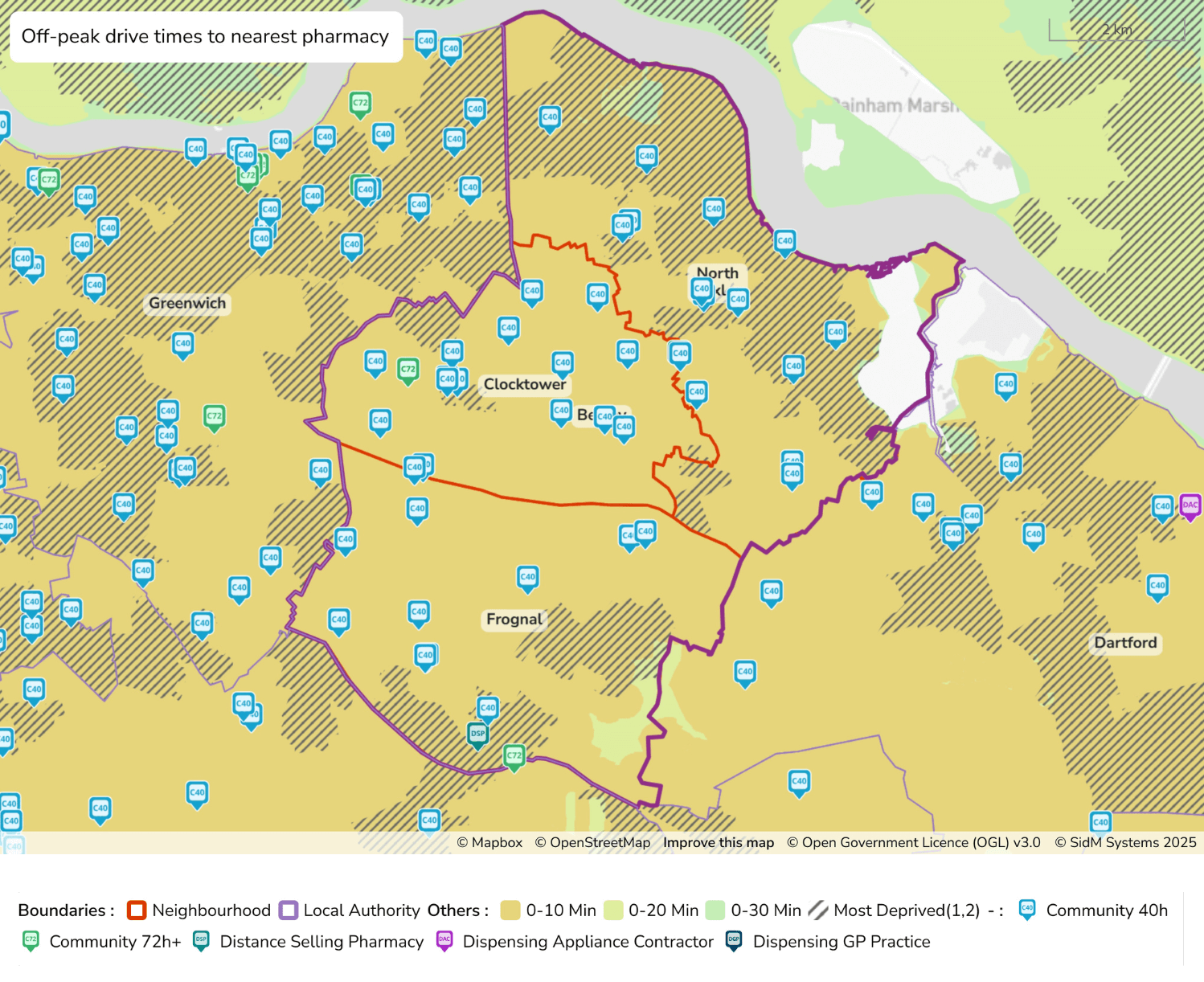
Figure 14 - text description
- This map shows estimated off-peak driving times to the nearest pharmacy across the London Borough of Bexley and surrounding areas, including parts of Greenwich and Dartford. The map is colour-coded to reflect drive times: orange areas indicate locations within a 0–10 minute drive, light green areas represent 0–20 minutes, and green areas cover up to 30 minutes. A substantial portion of the map, particularly within Bexley, falls within the 0–10 minute drive zone, suggesting generally high accessibility by car. In particular, Frognal and Clocktower are almost completely coloured orange, showing high accessibility to pharmacies via off peak driving times in these two areas. Areas marked with diagonal black hatching highlight the most deprived zones (in the bottom two national deprivation deciles), and these zones are predominantly found in North Bexley and Greenwich. Pharmacy types are marked with distinct icons: light blue “C40” icons represent community pharmacies open 40 or more hours per week and are the most widely distributed; green “C72” icons show community pharmacies open 72 or more hours; teal icons indicate distance selling pharmacies. Localities are outlined in orange, and the broader Bexley local authority boundary is marked in purple. Most of the most deprived areas fall within the 10-minute drive range, highlighting a strong level of pharmacy accessibility for those with access to private vehicles.
Figure 15: Map to show drive times by car to the nearest pharmacy in Bexley (peak)
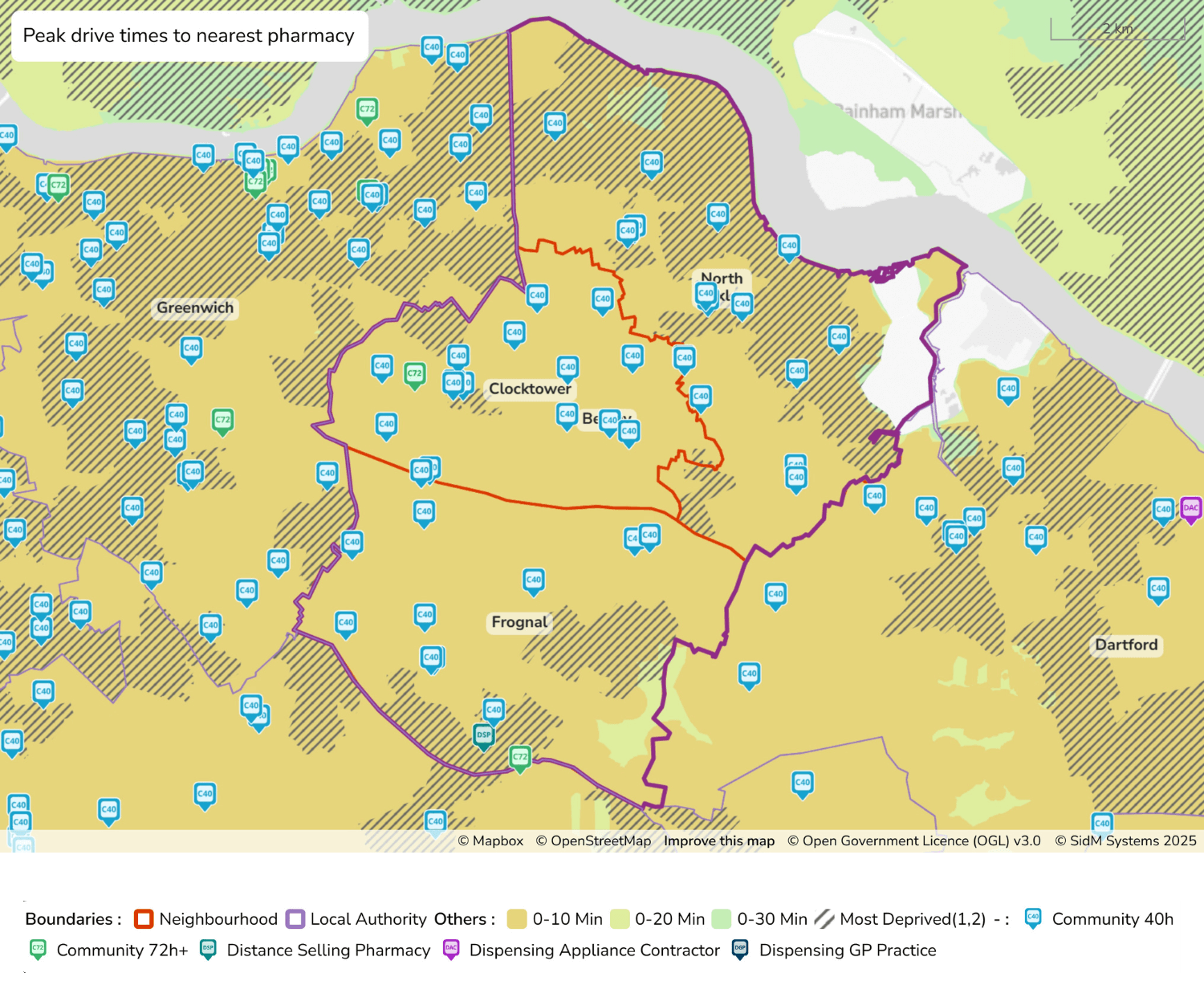
Figure 15 - text description
- This map shows estimated peak driving times to the nearest pharmacy across the London Borough of Bexley and surrounding areas, including parts of Greenwich and Dartford. The map is colour-coded to reflect drive times: orange areas indicate locations within a 0–10 minute drive, light green areas represent 0–20 minutes, and green areas cover up to 30 minutes. A substantial portion of the map, particularly within Bexley, falls within the 0–10 minute drive zone, suggesting generally high accessibility by car. In particular, Frognal and Clocktower are almost completely coloured orange, showing high accessibility to pharmacies via peak driving times in these two areas. Areas marked with diagonal black hatching highlight the most deprived zones (in the bottom two national deprivation deciles), and these zones are predominantly found in North Bexley and Greenwich. Pharmacy types are marked with distinct icons: light blue “C40” icons represent community pharmacies open 40 or more hours per week and are the most widely distributed; green “C72” icons show community pharmacies open 72 or more hours; teal icons indicate distance selling pharmacies. Localities are outlined in orange, and the broader Bexley local authority boundary is marked in purple. Most of the most deprived areas fall within the 10-minute drive range, highlighting a strong level of pharmacy accessibility for those with access to private vehicles.
Figure 16: Map to show public transport times to the nearest pharmacy in Bexley (off peak)
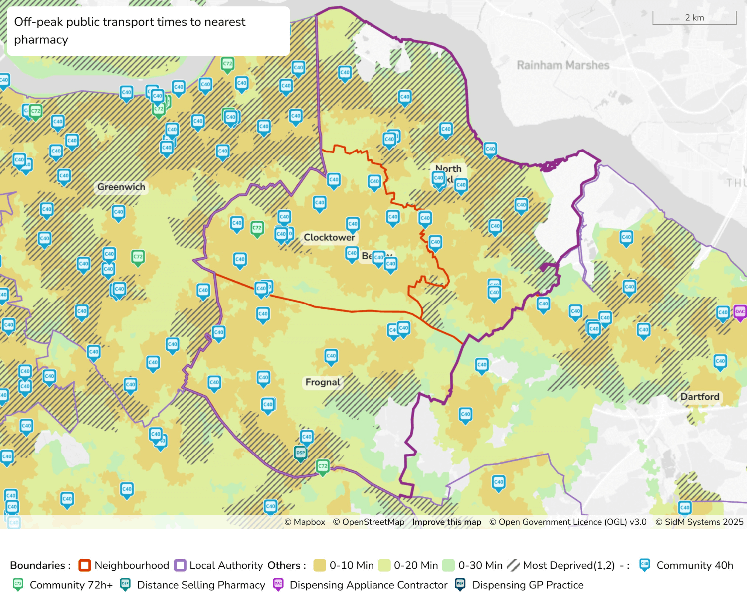
Figure 16 - text description
- This map shows estimated off-peak public transport travel times to the nearest pharmacy across the London Borough of Bexley and surrounding areas, including parts of Greenwich and Dartford. The map is colour-coded to reflect drive times: orange areas indicate locations within a 0–10 minute drive, light green areas represent 0–20 minutes, and green areas cover up to 30 minutes. Overlaid on this are black diagonal hatching patterns, which mark areas that fall within the most deprived national deciles (1 and 2). Pharmacy types are marked with distinct icons: light blue “C40” icons represent community pharmacies open 40 or more hours per week and are the most widely distributed; green “C72” icons show community pharmacies open 72 or more hours; teal icons indicate distance selling pharmacies. Locality boundaries are marked in orange, and the Bexley local authority boundary is outlined in purple. The majority of the borough is within a 20-minute public transport journey to a pharmacy, particularly in Frognal and Clocktower, which is even more accessible with most of the locality being within 10 minutes from a pharmacy via public transport. However, several zones—especially on the borough’s edges—fall into the 20–30 minute range, in particular the northern region of North Bexley, the northeast of the borough, and the southeast of Frognal.
Figure 17: Map to show public transport times to the nearest pharmacy in Bexley (peak)
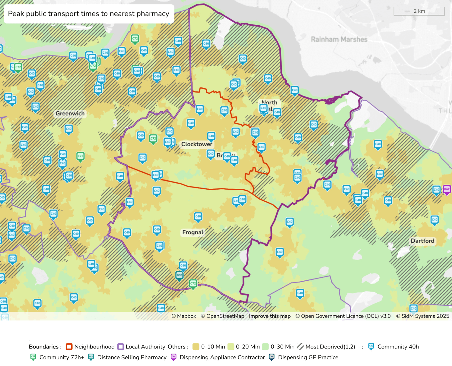
Figure 17 - text description
- This map shows estimated peak public transport travel times to the nearest pharmacy across the London Borough of Bexley and surrounding areas, including parts of Greenwich and Dartford. The map is colour-coded to reflect drive times: orange areas indicate locations within a 0–10 minute drive, light green areas represent 0–20 minutes, and green areas cover up to 30 minutes. Overlaid on this are black diagonal hatching patterns, which mark areas that fall within the most deprived national deciles (1 and 2). Pharmacy types are marked with distinct icons: light blue “C40” icons represent community pharmacies open 40 or more hours per week and are the most widely distributed; green “C72” icons show community pharmacies open 72 or more hours; teal icons indicate distance selling pharmacies. Locality boundaries are marked in orange, and the Bexley local authority boundary is outlined in purple. The majority of the borough is within a 20-minute public transport journey to a pharmacy, particularly in Frognal and Clocktower, which is even more accessible with most of the locality being within 10 minutes from a pharmacy via public transport. However, several zones, especially on the borough’s edges fall into the 20–30 minute range, in particular the northern region of North Bexley, the northeast of the borough, and a small area in the southeast of Frognal.
3.2.3.2 Routine weekday evening access to community pharmacies
The number, location and opening hours of community pharmacy providers open beyond 6 pm, Monday to Friday (excluding bank holidays), vary within each locality; they are listed in the table below and seen in Figure 17. Full details of all pharmacies’ opening hours can be found in Appendix A. ‘Average’ access is difficult, given the variety of opening hours and locations. Access is therefore considered at locality level and can be found in Table 42, which shows that 53% of pharmacies are open beyond 6pm across Bexley.
| Locality | Number and percentage of pharmacies open beyond 6 pm | Number and percentage of pharmacies open on Saturday | Number and percentage of pharmacies open on Sunday |
|---|---|---|---|
| North Bexley | 8 (50%) | 15 (94%) | 1 (6%) |
| Clocktower | 7 (47%) | 12 (80%) | 2 (13%) |
| Frognal | 9 (64%) | 13 (93%) | 1 (7%) |
| Bexley | 24 (53%) | 40 (89%) | 4 (9%) |
Figure 18: Map to show pharmacy opening hours (weekday)
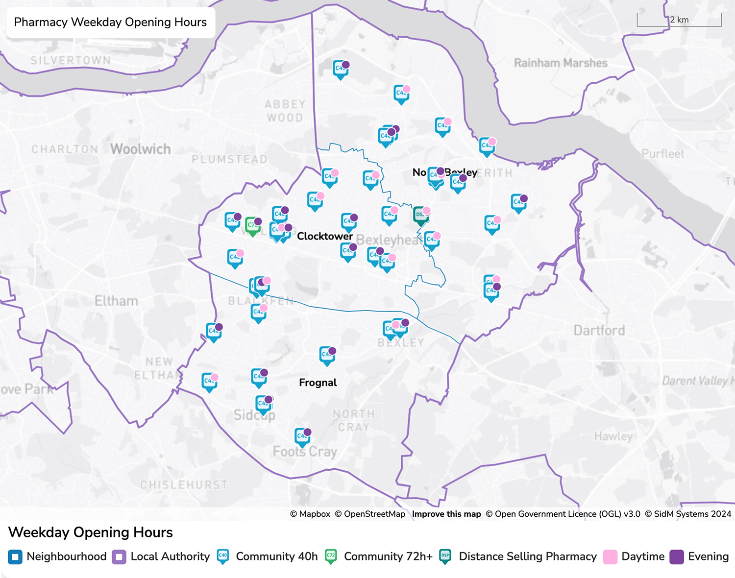
Figure 18 - text description
- This map displays the weekday opening hours of pharmacies across the London Borough of Bexley. Pharmacies are categorised by both service type and the time of day they operate. All pharmacies are represented with icons based on their type: light blue “C40” icons for community pharmacies open 40 or more hours per week, green “C72” icons for those open 72+ hours, and teal icons for distance selling pharmacies. Overlaying these icons, there are pink circular indicators to show pharmacies offering daytime weekday opening hours, or purple circular indicators to mark those open into the evening. The majority of pharmacies provide daytime access, with a noticeable cluster offering evening hours particularly in the central and northern areas of Bexley. Localities are outlined in blue, and the boundary of Bexley as a local authority is marked in purple.
3.2.3.3 Routine Saturday daytime access to community pharmacies
The number, location and opening hours of community pharmacy providers open on Saturdays vary within each locality. Of the pharmacies in Bexley, 89% are open on Saturdays, the majority of which are open into the late afternoon. ‘Average’ access is difficult given the variety of opening hours and locations. Access is therefore considered at locality level. Full details of all pharmacies open on a Saturday can be found in Appendix A and in Figure 19 below.
3.2.3.4 Routine Sunday daytime access to community pharmacies
The number, location and opening hours of community pharmacy providers open on Sundays vary within each locality. Fewer pharmacies (9%) are open on Sundays than any other day in Bexley, which typically mirrors availability of other healthcare providers open on a Sunday. Full details of all pharmacies open on a Sunday can be found in Appendix A and in Figure 19 below.
Figure 19: Pharmacy opening hours (weekend)
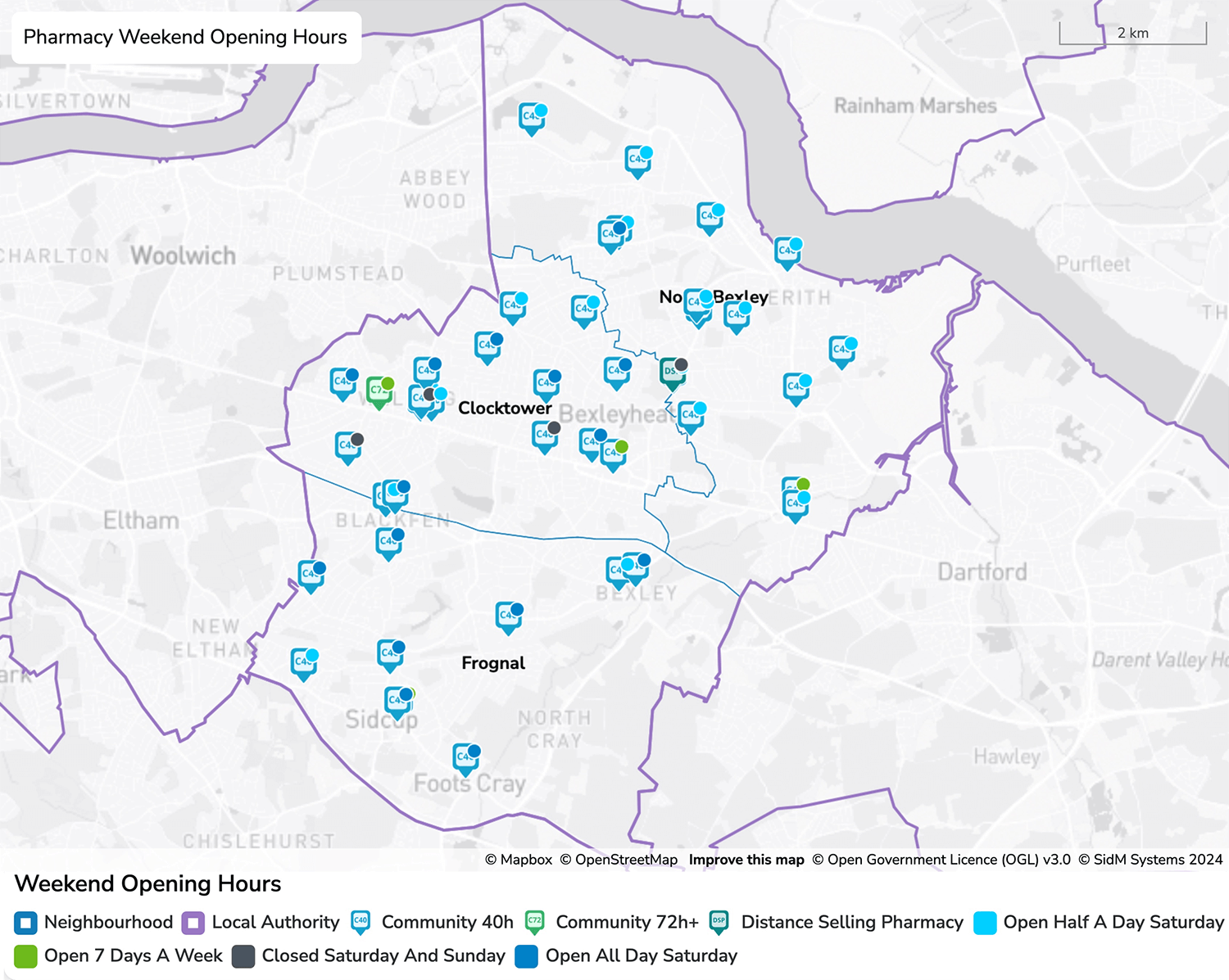
Figure 19 - text description
- This map illustrates the weekend opening hours of pharmacies in the London Borough of Bexley and nearby areas. Pharmacies are identified by several categories: most are marked with a light blue "C40" icon representing community pharmacies open 40 or more hours per week. Green “C72” icons are for those open 72+ hours, and teal icons for distance selling pharmacies. Overlaying these icons is a light blue circle indicating that the pharmacy is open half day Saturday or a dark blue circle indicating pharmacies that are open all-day Saturday. A few pharmacies are marked with green circular icons to denote those open 7 days a week and are predominantly located in Clocktower, offering full weekend accessibility. Conversely, pharmacies that are closed both Saturday and Sunday are marked with dark grey circles and are predominantly found in Clocktower too. The borough boundaries are marked in purple, and localities are outlined in blue. Pharmacies that operate extended weekend hours appear mostly clustered in central areas such as Clocktower, while the outskirts have fewer pharmacies open throughout the weekend such as the northern region of North Bexley. Frognal has a variety of pharmacies with some open for half a day on Saturday, some open all day Saturday, and one open 7 days a week.
3.2.3.5 Routine bank holiday access to community pharmacies
Community pharmacy contractors do not have to open on days which are specifically mentioned in the regulations (namely Christmas Day, Good Friday and Easter Sunday) or a day that has been specifically designated as a ‘bank holiday’, unless directed to open by NHSE.
Contractors also do not have to give formal notice of closures on these public and bank holidays but must ensure that their Directory of Services (DoS) and NHS website entries are accurate (this is now a terms of service requirement, with verification carried out quarterly).
As community pharmacies are not obliged to open on nominated bank holidays, many opt to close, however a number of pharmacies (often those in regional shopping centres, retail parks, supermarkets and major high streets) opt to open – often for limited hours.
The ICB has commissioned a Local Enhanced Service to provide coverage over Bank Holidays, Easter Sunday, and Christmas Day, to ensure that there are pharmacies open on these days so patients can access medication if required across Bexley. This is coordinated by the local Dentistry, Optometry and Pharmacy Team across London. However, any pharmacy may apply to open or be directed to open depending on need. It may also not be the same pharmacies on each bank holiday.
Details of which pharmacies are open can be found on the NHSE website.
3.2.4 Advanced Service provision from community pharmacy
Section 1.5.1.4.2 lists all Advanced Services that may be provided under the pharmacy contract. As these services are discretionary, not all providers will provide them all of the time.
Data supplied from NHS Business Services Authority (BSA) dispensing data has been used in Table 43 to demonstrate how many community pharmacies per locality have provided the Advanced Services, based on pharmacies claiming payment for the service. Details of individual pharmacy providers can be seen in Appendix A.
| North Bexley | Clocktower | Frognal | Bexley | |
|---|---|---|---|---|
| Pharmacy First service | 94% | 100% | 93% | 96% |
| Flu Vaccination service | 88% | 93% | 86% | 89% |
| Pharmacy Contraception Service | 44% | 60% | 57% | 53% |
| Hypertension case-finding service | 69% | 80% | 71% | 73% |
| New Medicine Service | 100% | 87% | 86% | 91% |
| Smoking Cessation Service | 0% | 0% | 0% | 0% |
| Appliance Use Review | 0% | 0% | 0% | 0% |
| Stoma Appliance Customisation | 0% | 0% | 0% | 0% |
| LFD service | 38% | 53% | 29% | 40% |
Source: NHS BSA Dispensing data September 2024 to January 2025.
It should be noted that some services, such as AUR and SAC have lower dispensing through Community Pharmacies as DACs (a specialised supplier of medical appliances and devices) provide these services. It should also be noted that for some of these services, such as AUR, not signing up does not preclude providers from providing the service.
Newer advanced services are increasing in activity based on activity recorded in the 2022 PNA. The Hypertension case finding service previously had low uptake across all districts however data suggests better uptake for the majority of contractors in all localities.
The Smoking Cessation Service currently has low uptake locally as well as nationally. This service relies on a referral from secondary care. Therefore, numbers should be interpreted with care.
More details on local and national trends can be found in the Community Pharmacy England Dashboards4.
3.2.5 Enhanced Service provision from community pharmacy
There are two National Enhanced Services and four Local Enhanced Services commissioned through community pharmacies in London.
The National Enhanced Services (NES) are the COVID-19 vaccination service and the RSV and Pertussis vaccination services.
- COVID-19 vaccination service: Actual provision numbers are not available at the time of writing, as this activity is seasonal and provision can change with each campaign. This service is also accessible to residents from other healthcare providers.
- The RSV vaccination and Pertussis vaccination service is currently under procurement and due to go live in autumn 2025.
The Local Enhanced Services (LES) are the bank holiday opening, MMR vaccination, Pneumococcal vaccination and London Flu vaccination.
- Bank holidays: As discussed in Section 3.2.3.5, there is a local enhanced service to ensure that there are pharmacies open on these days so patients can access medication if required. Providers typically changes each bank holiday, however provision is spread across the area and details can be found on the NHSE website: https://www.nhs.uk/service-search/pharmacy/find-a-pharmacy
- The Measles, Mumps and Rubella (MMR) vaccination service is currently commissioned to two pharmacies in Bexley:
- Aspire Pharmacy, 23 High Street, Sidcup, DA14 6EQ
- Belvedere Pharmacy, 11 Picardy Street, DA17 5QQ - Details of pharmacies signed up for the Pneumococcal Polysaccharide Vaccine (PPV) service were not available at the time of writing.
- The London Flu vaccination service will come into effect from 1 September 2025. In previous campaigns, one of the requirements for eligibility was for pharmacies to be providing the national Advanced Flu service first.
Any Locally Commissioned Services (LCS) commissioned by the ICB or the local authority are not considered here. They are outside the scope of the PNA but are considered in Section 4.
3.3 Dispensing Appliance Contractors
Dispensing Appliance Contractors (DACs) are described in Section 1.5.2. There are no DACs in Bexley. As part of the Essential Services of appliance contractors, a free delivery service is available to all patients. It is therefore likely that patients will obtain appliances delivered from DACs outside of Bexley. As of June 2024 there were a total of 111 DACs in England5.
3.4 Dispensing GP practices
Dispensing GP practices are described in Section 1.5.3. There are no dispensing GP practices in Bexley.
3.5 Pharmacy Access Scheme (PhAS) pharmacies
The Pharmacy Access Scheme is described in Section 1.5.1.5. There is one PhAS provider in Bexley, and details can be found in Appendix A.
3.6 Pharmaceutical service provision provided from outside Bexley
Bexley is bordered by three other HWB areas: Bromley, and Greenwich in London, and Kent. Bexley has good transport links and, as a result, it is anticipated that many residents in Bexley will have reasonable access to pharmaceutical service providers in neighbouring HWB areas and beyond.
It is not practical to list here all those pharmacies outside Bexley area by which Bexley residents will access pharmaceutical services. A number of providers lie within close proximity to the borders of Bexley, and the area boundaries are shown in Figure 11 in section 3.1.
Total items dispensed for Bexley between March 2024 and February 2025 (financial period) was 3,426,406. Of these items, 54% were dispensed by pharmacies in Bexley, and 46% dispensed in pharmacies outside Bexley. Of the total, 5% were dispensed by DSPs.